Paulba geodata
Paulba (Bicol) is a populated place; located in Philippines in Asia/Manila (GMT+8) time zone. With population of 2,468 people, there are 3349 cities with bigger population in this country. Compared to other cities in Philippines, 58.7% of cities are located further ↓South; 61.5% of cities are located further ←West and 72.4% of cities have lower elevation than Paulba. Note1


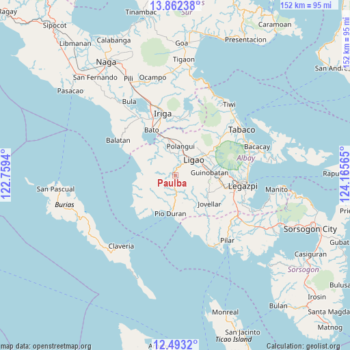
Paulba GPS coordinates[2]
13° 10' 43.5" North, 123° 27' 45.072" East
| Map corner | latitude | longitude |
|---|---|---|
| Upper-left | 13.86238°, | 122.7594° |
| Center: | 13.17875°, | 123.46252° |
| Lower-right: | 12.4932°, | 124.16565° |
| Map W x H: | 152.2×152.2 km | = 94.6×94.6mi |
| max Lat: | 20.78733° ⇑41.3% North |
| Paulba: | 13.17875° |
| min Lat: | ⇓58.7% South 4.65442° |
| min Long | Paulba | max Long |
| 117.04868° | 123.46252° | 126.58417° |
| W 61.5%⇐ | ⇒38.5% E |
Elevation
Elevation of Paulba is 59 m = 194 ft, and this is 28.9 m = 95 ft below average elevation for this country.
| Max E: |
2262 m = 7421 ft | 27.6% |
| Avg. | 87.9 m = 288 ft | |
| Paulba | 59 m = 194 ft | |
Min E: |
-2 m = -7 ft | 72.4% |
See also: Philippines elevation on elevation.city.
Geographical zone
Paulba is located in North Torrid zone (between Equator and Tropic of Cancer). Distance of this Northern Tropic circle is 1140.6 km =708.7 mi to North.| Distance of | km | miles | from Paulba |
|---|---|---|---|
| North Pole | 8541.7 | 5307.6 | to North |
| Arctic Circle | 5935.8 | 3688.3 | to North |
| Tropic Cancer | 1140.6 | 708.7 | to North |
| Equator | 1465.3 | 910.5 | to South |


Nearby cities:
15 places around Paulba: (largest is in red/bold)
• Batana
13.5 km =8.4 mi,  54°
54°
• Binodegahan
13.1 km =8.1 mi,  182°
182°
• Bonga
10.4 km =6.5 mi,  65°
65°
• Burabod
11.2 km =7 mi,  333°
333°
• City of Ligao
7 km =4.3 mi, 52°
• Iraya
9.9 km =6.2 mi,  36°
36°
• Libon
13.7 km =8.5 mi,  349°
349°
• Ligao
7.5 km =4.7 mi,  55°
55°
• Manga
10.4 km =6.5 mi,  359°
359°
• Polangui
12.9 km =8 mi,  11°
11°
• Sagrada Familia
12.2 km =7.6 mi, 325°
• San Jose
12.4 km =7.7 mi,  307°
307°
• San Vicente
9.7 km =6 mi,  341°
341°
• Tinampo
7.3 km =4.5 mi, 41°
• Tuburan
12 km =7.5 mi, 54°
Sources, notices
• [Note1] Compared only with cities in Philippines existing in our database
• [Src1] Map data: © OpenStreetMap contributors (CC-BY-SA)
• [Src2] Other city data from geonames.org with taken over terms of usage.
• [Src3] Geographical zone / Annual Mean Temperature by Robert A. Rohde @ Wikipedia
