Binodegahan geodata
Binodegahan (Bicol) is a populated place; located in Philippines in Asia/Manila (GMT+8) time zone. With population of 2,471 people, there are 3345 cities with bigger population in this country. Compared to other cities in Philippines, 57.9% of cities are located further ↓South; 61.4% of cities are located further ←West and 77.7% of cities have lower elevation than Binodegahan. Note1


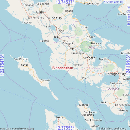
Binodegahan GPS coordinates[2]
13° 3' 41.04" North, 123° 27' 28.44" East
| Map corner | latitude | longitude |
|---|---|---|
| Upper-left | 13.74537°, | 122.75478° |
| Center: | 13.0614°, | 123.4579° |
| Lower-right: | 12.37553°, | 124.16103° |
| Map W x H: | 152.3×152.3 km | = 94.6×94.6mi |
| max Lat: | 20.78733° ⇑42.1% North |
| Binodegahan: | 13.0614° |
| min Lat: | ⇓57.9% South 4.65442° |
| min Long | Binodegahan | max Long |
| 117.04868° | 123.4579° | 126.58417° |
| W 61.4%⇐ | ⇒38.6% E |
Elevation
Elevation of Binodegahan is 79 m = 259 ft, and this is 8.9 m = 29 ft below average elevation for this country.
| Max E: |
2262 m = 7421 ft | 22.3% |
| Avg. | 87.9 m = 288 ft | |
| Binodegahan | 79 m = 259 ft | |
Min E: |
-2 m = -7 ft | 77.7% |
See also: Philippines elevation on elevation.city.
Geographical zone
Binodegahan is located in North Torrid zone (between Equator and Tropic of Cancer). Distance of this Northern Tropic circle is 1153.6 km =716.8 mi to North.| Distance of | km | miles | from Binodegahan |
|---|---|---|---|
| North Pole | 8554.8 | 5315.7 | to North |
| Arctic Circle | 5948.9 | 3696.5 | to North |
| Tropic Cancer | 1153.6 | 716.8 | to North |
| Equator | 1452.3 | 902.4 | to South |


Nearby cities:
15 places around Binodegahan: (largest is in red/bold)
• Apud
20 km =12.4 mi,  295°
295°
• Badian
16.6 km =10.3 mi,  258°
258°
• Basicao Coastal
6.1 km =3.8 mi,  253°
253°
• Bonga
19.9 km =12.4 mi,  30°
30°
• Cagmanaba
17.4 km =10.8 mi,  267°
267°
• City of Ligao
18.3 km =11.4 mi,  19°
19°
• Jovellar
15.4 km =9.6 mi,  86°
86°
• Ligao
18.5 km =11.5 mi, 21°
• Malidong
5.3 km =3.3 mi,  178°
178°
• Maonon
9.8 km =6.1 mi, 253°
• Mauraro
17.8 km =11.1 mi,  56°
56°
• Paulba
13.1 km =8.1 mi,  2°
2°
• Pio Duran
3.8 km =2.4 mi,  201°
201°
• Salvacion
17.2 km =10.7 mi, 88°
• Tinampo
19.3 km =12 mi, 16°
Sources, notices
• [Note1] Compared only with cities in Philippines existing in our database
• [Src1] Map data: © OpenStreetMap contributors (CC-BY-SA)
• [Src2] Other city data from geonames.org with taken over terms of usage.
• [Src3] Geographical zone / Annual Mean Temperature by Robert A. Rohde @ Wikipedia
