Patawag geodata
Patawag (Zamboanga Peninsula) is a populated place; located in Philippines in Asia/Manila (GMT+8) time zone. With population of 2,279 people, there are 3724 cities with bigger population in this country. Compared to other cities in Philippines, 81.6% of cities are located further ↑North; 52.7% of cities are located further →East and 100% of cities have higher elevation than Patawag. Note1
Administrative division(s):
- Level 1: Zamboanga Peninsula
- Level 2: Province of Zamboanga del Norte
- Level 3: Labason


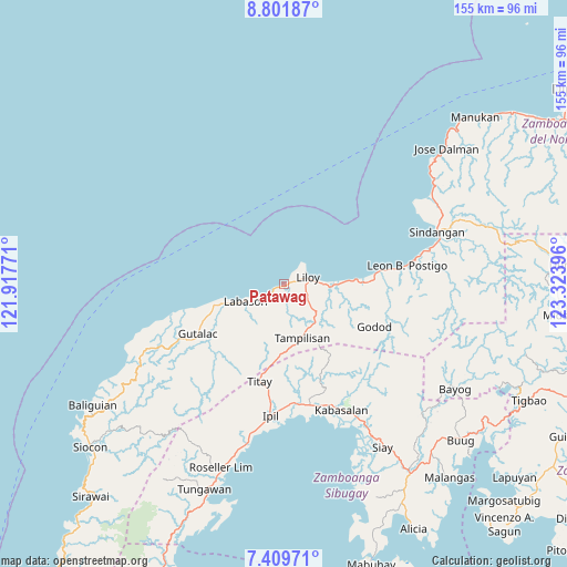
Patawag GPS coordinates[2]
8° 6' 23.004" North, 122° 37' 14.988" East
| Map corner | latitude | longitude |
|---|---|---|
| Upper-left | 8.80187°, | 121.91771° |
| Center: | 8.10639°, | 122.62083° |
| Lower-right: | 7.40971°, | 123.32396° |
| Map W x H: | 154.8×154.8 km | = 96.2×96.2mi |
| max Lat: | 20.78733° ⇑81.6% North |
| Patawag: | 8.10639° |
| min Lat: | ⇓18.4% South 4.65442° |
| min Long | Patawag | max Long |
| 117.04868° | 122.62083° | 126.58417° |
| W 47.3%⇐ | ⇒52.7% E |
Elevation
Elevation of Patawag is 0 m = 0 ft, and this is 87.9 m = 288 ft below average elevation for this country.
| Max E: |
2262 m = 7421 ft | 100% |
| Avg. | 87.9 m = 288 ft | |
| Patawag | 0 m = 0 ft | |
Min E: |
-2 m = -7 ft | 0% |
See also: Philippines elevation on elevation.city.
Geographical zone
Patawag is located in North Torrid zone (between Equator and Tropic of Cancer). Distance of Equator is 901.3 km =560 mi to South.| Distance of | km | miles | from Patawag |
|---|---|---|---|
| North Pole | 9105.7 | 5658 | to North |
| Arctic Circle | 6499.8 | 4038.8 | to North |
| Tropic Cancer | 1704.6 | 1059.2 | to North |
| Equator | 901.3 | 560 | to South |


Nearby cities:
15 places around Patawag: (largest is in red/bold)
• Caracal
24.8 km =15.4 mi,  84°
84°
• Dalangin
28.8 km =17.9 mi,  189°
189°
• Gutalac
27.5 km =17.1 mi,  239°
239°
• Ipil
36 km =22.4 mi, 186°
• Kabasalan
37.9 km =23.5 mi,  155°
155°
• Kalawit
12.3 km =7.6 mi,  248°
248°
• Kipit
11.8 km =7.3 mi, 235°
• Labason
11.7 km =7.3 mi, 249°
• Leon Postigo
34.6 km =21.5 mi, 80°
• Liloy
4.3 km =2.7 mi, 78°
• Naga
40 km =24.9 mi, 159°
• Palomoc
21.7 km =13.5 mi, 191°
• Salug
17.9 km =11.1 mi,  87°
87°
• Tampilisan
12.1 km =7.5 mi,  145°
145°
• Titay
34 km =21.1 mi,  196°
196°
Sources, notices
• [Note1] Compared only with cities in Philippines existing in our database
• [Src1] Map data: © OpenStreetMap contributors (CC-BY-SA)
• [Src2] Other city data from geonames.org with taken over terms of usage.
• [Src3] Geographical zone / Annual Mean Temperature by Robert A. Rohde @ Wikipedia
