Kalawit geodata
Kalawit (Zamboanga Peninsula) is a populated place; located in Philippines in Asia/Manila (GMT+8) time zone. With population of 8,499 people, there are 730 cities with bigger population in this country. Compared to other cities in Philippines, 81.9% of cities are located further ↑North; 54.5% of cities are located further →East and 95.5% of cities have higher elevation than Kalawit. Note1
Administrative division(s):
- Level 1: Zamboanga Peninsula
- Level 2: Province of Zamboanga del Norte
- Level 3: Labason


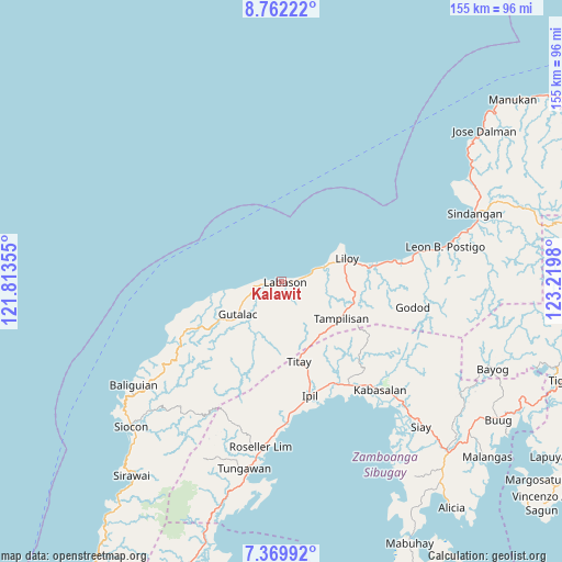
Kalawit GPS coordinates[2]
8° 4' 0.012" North, 122° 31' 0.012" East
| Map corner | latitude | longitude |
|---|---|---|
| Upper-left | 8.76222°, | 121.81355° |
| Center: | 8.06667°, | 122.51667° |
| Lower-right: | 7.36992°, | 123.2198° |
| Map W x H: | 154.8×154.8 km | = 96.2×96.2mi |
| max Lat: | 20.78733° ⇑81.9% North |
| Kalawit: | 8.06667° |
| min Lat: | ⇓18.1% South 4.65442° |
| min Long | Kalawit | max Long |
| 117.04868° | 122.51667° | 126.58417° |
| W 45.5%⇐ | ⇒54.5% E |
Elevation
Elevation of Kalawit is 5 m = 16 ft, and this is 82.9 m = 272 ft below average elevation for this country.
| Max E: |
2262 m = 7421 ft | 95.5% |
| Avg. | 87.9 m = 288 ft | |
| Kalawit | 5 m = 16 ft | |
Min E: |
-2 m = -7 ft | 4.5% |
See also: Philippines elevation on elevation.city.
Geographical zone
Kalawit is located in North Torrid zone (between Equator and Tropic of Cancer). Distance of Equator is 896.9 km =557.3 mi to South.| Distance of | km | miles | from Kalawit |
|---|---|---|---|
| North Pole | 9110.1 | 5660.8 | to North |
| Arctic Circle | 6504.2 | 4041.5 | to North |
| Tropic Cancer | 1709 | 1061.9 | to North |
| Equator | 896.9 | 557.3 | to South |


Nearby cities:
15 places around Kalawit: (largest is in red/bold)
• Caracal
36.8 km =22.9 mi,  79°
79°
• Dalangin
25 km =15.5 mi,  164°
164°
• Gutalac
15.5 km =9.6 mi,  232°
232°
• Ipil
32.3 km =20.1 mi,  166°
166°
• Kabasalan
40.6 km =25.2 mi,  137°
137°
• Kipit
2.9 km =1.8 mi, 143°
• Labason
0.6 km =0.4 mi,  63°
63°
• Liloy
16.6 km =10.3 mi,  71°
71°
• Naga
41.8 km =26 mi, 141°
• Palomoc
18.3 km =11.4 mi, 156°
• Patawag
12.3 km =7.6 mi, 68°
• Roseller Lim
46 km =28.6 mi,  186°
186°
• Salug
29.8 km =18.5 mi, 79°
• Tampilisan
19.2 km =11.9 mi,  106°
106°
• Titay
28.3 km =17.6 mi,  176°
176°
Sources, notices
• [Note1] Compared only with cities in Philippines existing in our database
• [Src1] Map data: © OpenStreetMap contributors (CC-BY-SA)
• [Src2] Other city data from geonames.org with taken over terms of usage.
• [Src3] Geographical zone / Annual Mean Temperature by Robert A. Rohde @ Wikipedia
