Daanbantayan geodata
Daanbantayan (Central Visayas) is a seat of a third-order administrative division; located in Philippines in Asia/Manila (GMT+8) time zone. With population of 13,439 people, there are 485 cities with bigger population in this country. Compared to other cities in Philippines, 53.9% of cities are located further ↑North; 71.3% of cities are located further ←West and 89.7% of cities have higher elevation than Daanbantayan. Note1
Administrative division(s):
- Level 1: Central Visayas
- Level 2: Province of Cebu
- Level 3: Daanbantayan


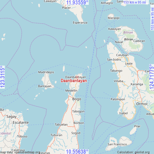
Daanbantayan GPS coordinates[2]
11° 14' 48.516" North, 124° 0' 52.632" East
| Map corner | latitude | longitude |
|---|---|---|
| Upper-left | 11.93559°, | 123.3115° |
| Center: | 11.24681°, | 124.01462° |
| Lower-right: | 10.55638°, | 124.71775° |
| Map W x H: | 153.4×153.4 km | = 95.3×95.3mi |
| max Lat: | 20.78733° ⇑53.9% North |
| Daanbantayan: | 11.24681° |
| min Lat: | ⇓46.1% South 4.65442° |
| min Long | Daanbantayan | max Long |
| 117.04868° | 124.01462° | 126.58417° |
| W 71.3%⇐ | ⇒28.7% E |
Elevation
Elevation of Daanbantayan is 7 m = 23 ft, and this is 80.9 m = 265 ft below average elevation for this country.
| Max E: |
2262 m = 7421 ft | 89.7% |
| Avg. | 87.9 m = 288 ft | |
| Daanbantayan | 7 m = 23 ft | |
Min E: |
-2 m = -7 ft | 10.3% |
See also: Philippines elevation on elevation.city.
Geographical zone
Daanbantayan is located in North Torrid zone (between Equator and Tropic of Cancer). Distance of Equator is 1250.5 km =777 mi to South.| Distance of | km | miles | from Daanbantayan |
|---|---|---|---|
| North Pole | 8756.5 | 5441 | to North |
| Arctic Circle | 6150.6 | 3821.8 | to North |
| Tropic Cancer | 1355.4 | 842.2 | to North |
| Equator | 1250.5 | 777 | to South |


Nearby cities:
15 places around Daanbantayan: (largest is in red/bold)
• Antipolo
11.4 km =7.1 mi,  218°
218°
• Bachauan
7.1 km =4.4 mi,  231°
231°
• Bagay
6 km =3.7 mi,  158°
158°
• Biton
2.3 km =1.4 mi, 226°
• Calape
8.2 km =5.1 mi,  165°
165°
• Kauit
10.1 km =6.3 mi, 227°
• Lanao
1.5 km =0.9 mi,  44°
44°
• Maya
5.4 km =3.4 mi,  55°
55°
• Pajo
0.8 km =0.5 mi,  214°
214°
• Panognawan
9.5 km =5.9 mi,  186°
186°
• Paypay
5.5 km =3.4 mi, 230°
• Talisay
4.4 km =2.7 mi,  92°
92°
• Tapilon
3.8 km =2.4 mi,  27°
27°
• Tinubuan
6.8 km =4.2 mi, 186°
• Tominhao
2.6 km =1.6 mi,  118°
118°
Sources, notices
• [Note1] Compared only with cities in Philippines existing in our database
• [Src1] Map data: © OpenStreetMap contributors (CC-BY-SA)
• [Src2] Other city data from geonames.org with taken over terms of usage.
• [Src3] Geographical zone / Annual Mean Temperature by Robert A. Rohde @ Wikipedia
