Panacan geodata
Panacan (Mimaropa) is a populated place; located in Philippines in Asia/Manila (GMT+8) time zone. With population of 10,526 people, there are 588 cities with bigger population in this country. Compared to other cities in Philippines, 74.3% of cities are located further ↑North; 99.3% of cities are located further →East and 89.7% of cities have higher elevation than Panacan. Note1


Panacan GPS coordinates[2]
9° 14' 46.572" North, 118° 24' 29.52" East
| Map corner | latitude | longitude |
|---|---|---|
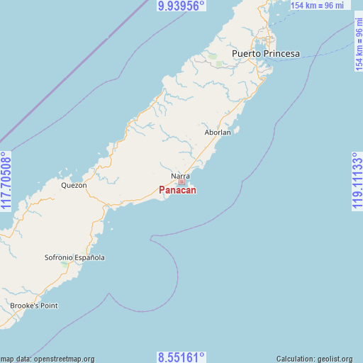
| Upper-left | 9.93956°, | 117.70508° |
| Center: | 9.24627°, | 118.4082° |
| Lower-right: | 8.55161°, | 119.11133° |
| Map W x H: | 154.3×154.3 km | = 95.9×95.9mi |
| max Lat: | 20.78733° ⇑74.3% North |
| Panacan: | 9.24627° |
| min Lat: | ⇓25.7% South 4.65442° |
| min Long | Panacan | max Long |
| 117.04868° | 118.4082° | 126.58417° |
| W 0.7%⇐ | ⇒99.3% E |
Elevation
Elevation of Panacan is 7 m = 23 ft, and this is 80.9 m = 265 ft below average elevation for this country.
| Max E: |
2262 m = 7421 ft | 89.7% |
| Avg. | 87.9 m = 288 ft | |
| Panacan | 7 m = 23 ft | |
Min E: |
-2 m = -7 ft | 10.3% |
See also: Philippines elevation on elevation.city.
Geographical zone
Panacan is located in North Torrid zone (between Equator and Tropic of Cancer). Distance of Equator is 1028.1 km =638.8 mi to South.| Distance of | km | miles | from Panacan |
|---|---|---|---|
| North Pole | 8979 | 5579.3 | to North |
| Arctic Circle | 6373.1 | 3960.1 | to North |
| Tropic Cancer | 1577.8 | 980.4 | to North |
| Equator | 1028.1 | 638.8 | to South |


Nearby cities:
15 places around Panacan: (largest is in red/bold)
• Aborlan
25.9 km =16.1 mi,  36°
36°
• Apurawan
39.8 km =24.7 mi,  350°
350°
• Aramawayan
29 km =18 mi,  291°
291°
• Aramayuan
25.7 km =16 mi,  250°
250°
• Burirao
34.2 km =21.3 mi,  261°
261°
• Calatugas
22 km =13.7 mi, 247°
• Iraray
48.2 km =30 mi,  234°
234°
• Isugod
33.4 km =20.8 mi, 288°
• Labog
44.7 km =27.8 mi,  241°
241°
• Narra
2.5 km =1.6 mi, 350°
• Panitian
39.1 km =24.3 mi, 244°
• Plaridel
17.9 km =11.1 mi,  34°
34°
• Punang
46.9 km =29.1 mi, 237°
• Quezon
41.4 km =25.7 mi,  269°
269°
• Tabon
45.4 km =28.2 mi, 268°
Sources, notices
• [Note1] Compared only with cities in Philippines existing in our database
• [Src1] Map data: © OpenStreetMap contributors (CC-BY-SA)
• [Src2] Other city data from geonames.org with taken over terms of usage.
• [Src3] Geographical zone / Annual Mean Temperature by Robert A. Rohde @ Wikipedia
