Apurawan geodata
Apurawan (Mimaropa) is a populated place; located in Philippines in Asia/Manila (GMT+8) time zone. With population of 2,943 people, there are 2596 cities with bigger population in this country. Compared to other cities in Philippines, 72.6% of cities are located further ↑North; 99.4% of cities are located further →East and 80.7% of cities have higher elevation than Apurawan. Note1


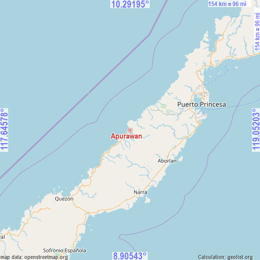
Apurawan GPS coordinates[2]
9° 35' 57.84" North, 118° 20' 56.04" East
| Map corner | latitude | longitude |
|---|---|---|
| Upper-left | 10.29195°, | 117.64578° |
| Center: | 9.5994°, | 118.3489° |
| Lower-right: | 8.90543°, | 119.05203° |
| Map W x H: | 154.2×154.2 km | = 95.8×95.8mi |
| max Lat: | 20.78733° ⇑72.6% North |
| Apurawan: | 9.5994° |
| min Lat: | ⇓27.4% South 4.65442° |
| min Long | Apurawan | max Long |
| 117.04868° | 118.3489° | 126.58417° |
| W 0.6%⇐ | ⇒99.4% E |
Elevation
Elevation of Apurawan is 9 m = 30 ft, and this is 78.9 m = 259 ft below average elevation for this country.
| Max E: |
2262 m = 7421 ft | 80.7% |
| Avg. | 87.9 m = 288 ft | |
| Apurawan | 9 m = 30 ft | |
Min E: |
-2 m = -7 ft | 19.3% |
See also: Philippines elevation on elevation.city.
Geographical zone
Apurawan is located in North Torrid zone (between Equator and Tropic of Cancer). Distance of Equator is 1067.4 km =663.3 mi to South.| Distance of | km | miles | from Apurawan |
|---|---|---|---|
| North Pole | 8939.7 | 5554.9 | to North |
| Arctic Circle | 6333.8 | 3935.6 | to North |
| Tropic Cancer | 1538.6 | 956 | to North |
| Equator | 1067.4 | 663.3 | to South |


Nearby cities:
15 places around Apurawan: (largest is in red/bold)
• Aborlan
28.6 km =17.8 mi,  130°
130°
• Aramawayan
35.1 km =21.8 mi,  215°
215°
• Aramayuan
50.9 km =31.6 mi,  200°
200°
• Bacungan
51.9 km =32.2 mi,  48°
48°
• Burirao
52.1 km =32.4 mi,  211°
211°
• Calatugas
49.8 km =30.9 mi, 196°
• Irahuan
44.2 km =27.5 mi,  58°
58°
• Isugod
38.2 km =23.7 mi, 221°
• Narra
37.3 km =23.2 mi,  170°
170°
• Panacan
39.8 km =24.7 mi, 170°
• Plaridel
29.7 km =18.5 mi,  145°
145°
• Puerto Princesa
45.1 km =28 mi,  69°
69°
• Quezon
52.9 km =32.9 mi, 221°
• San Jose
50 km =31.1 mi, 63°
• Tagburos
49.1 km =30.5 mi, 58°
Sources, notices
• [Note1] Compared only with cities in Philippines existing in our database
• [Src1] Map data: © OpenStreetMap contributors (CC-BY-SA)
• [Src2] Other city data from geonames.org with taken over terms of usage.
• [Src3] Geographical zone / Annual Mean Temperature by Robert A. Rohde @ Wikipedia
