Aborlan geodata
Aborlan (Mimaropa) is a populated place; located in Philippines in Asia/Manila (GMT+8) time zone. With population of 4,790 people, there are 1379 cities with bigger population in this country. Compared to other cities in Philippines, 73.5% of cities are located further ↑North; 99.3% of cities are located further →East and 73.2% of cities have higher elevation than Aborlan. Note1


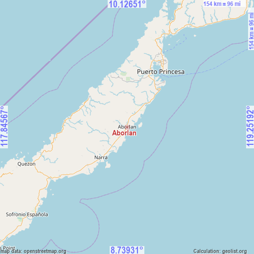
Aborlan GPS coordinates[2]
9° 26' 0.996" North, 118° 32' 55.644" East
| Map corner | latitude | longitude |
|---|---|---|
| Upper-left | 10.12651°, | 117.84567° |
| Center: | 9.43361°, | 118.54879° |
| Lower-right: | 8.73931°, | 119.25192° |
| Map W x H: | 154.2×154.2 km | = 95.8×95.8mi |
| max Lat: | 20.78733° ⇑73.5% North |
| Aborlan: | 9.43361° |
| min Lat: | ⇓26.5% South 4.65442° |
| min Long | Aborlan | max Long |
| 117.04868° | 118.54879° | 126.58417° |
| W 0.7%⇐ | ⇒99.3% E |
Elevation
Elevation of Aborlan is 11 m = 36 ft, and this is 76.9 m = 252 ft below average elevation for this country.
| Max E: |
2262 m = 7421 ft | 73.2% |
| Avg. | 87.9 m = 288 ft | |
| Aborlan | 11 m = 36 ft | |
Min E: |
-2 m = -7 ft | 26.8% |
See also: Philippines elevation on elevation.city.
Geographical zone
Aborlan is located in North Torrid zone (between Equator and Tropic of Cancer). Distance of Equator is 1048.9 km =651.8 mi to South.| Distance of | km | miles | from Aborlan |
|---|---|---|---|
| North Pole | 8958.1 | 5566.3 | to North |
| Arctic Circle | 6352.3 | 3947.1 | to North |
| Tropic Cancer | 1557 | 967.5 | to North |
| Equator | 1048.9 | 651.8 | to South |


Nearby cities:
15 places around Aborlan: (largest is in red/bold)
• Apurawan
28.6 km =17.8 mi,  310°
310°
• Aramawayan
43.6 km =27.1 mi,  256°
256°
• Aramayuan
49.3 km =30.6 mi,  233°
233°
• Bacungan
55.6 km =34.5 mi,  17°
17°
• Burirao
55.7 km =34.6 mi,  242°
242°
• Calatugas
46.3 km =28.8 mi, 230°
• Irahuan
44.5 km =27.7 mi, 20°
• Isugod
48.2 km =30 mi, 257°
• Narra
24.2 km =15 mi,  220°
220°
• Panacan
25.9 km =16.1 mi, 216°
• Plaridel
8 km =5 mi, 220°
• Puerto Princesa
39.7 km =24.7 mi,  31°
31°
• Quezon
60.7 km =37.7 mi,  249°
249°
• San Jose
46.7 km =29 mi, 29°
• Tagburos
48.3 km =30 mi, 24°
Sources, notices
• [Note1] Compared only with cities in Philippines existing in our database
• [Src1] Map data: © OpenStreetMap contributors (CC-BY-SA)
• [Src2] Other city data from geonames.org with taken over terms of usage.
• [Src3] Geographical zone / Annual Mean Temperature by Robert A. Rohde @ Wikipedia
