Pambuhan geodata
Pambuhan (Bicol) is a populated place; located in Philippines in Asia/Manila (GMT+8) time zone. With population of 2,526 people, there are 3249 cities with bigger population in this country. Compared to other cities in Philippines, 68.7% of cities are located further ↓South; 54.8% of cities are located further ←West and 85.4% of cities have higher elevation than Pambuhan. Note1


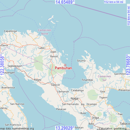
Pambuhan GPS coordinates[2]
13° 58' 24.96" North, 123° 5' 1.32" East
| Map corner | latitude | longitude |
|---|---|---|
| Upper-left | 14.65489°, | 122.38058° |
| Center: | 13.9736°, | 123.0837° |
| Lower-right: | 13.29029°, | 123.78683° |
| Map W x H: | 151.7×151.7 km | = 94.3×94.3mi |
| max Lat: | 20.78733° ⇑31.3% North |
| Pambuhan: | 13.9736° |
| min Lat: | ⇓68.7% South 4.65442° |
| min Long | Pambuhan | max Long |
| 117.04868° | 123.0837° | 126.58417° |
| W 54.8%⇐ | ⇒45.2% E |
Elevation
Elevation of Pambuhan is 8 m = 26 ft, and this is 79.9 m = 262 ft below average elevation for this country.
| Max E: |
2262 m = 7421 ft | 85.4% |
| Avg. | 87.9 m = 288 ft | |
| Pambuhan | 8 m = 26 ft | |
Min E: |
-2 m = -7 ft | 14.6% |
See also: Philippines elevation on elevation.city.
Geographical zone
Pambuhan is located in North Torrid zone (between Equator and Tropic of Cancer). Distance of this Northern Tropic circle is 1052.2 km =653.8 mi to North.| Distance of | km | miles | from Pambuhan |
|---|---|---|---|
| North Pole | 8453.3 | 5252.6 | to North |
| Arctic Circle | 5847.5 | 3633.5 | to North |
| Tropic Cancer | 1052.2 | 653.8 | to North |
| Equator | 1553.7 | 965.4 | to South |


Nearby cities:
15 places around Pambuhan: (largest is in red/bold)
• Barcelona
22.8 km =14.2 mi,  189°
189°
• Basud
16.4 km =10.2 mi,  308°
308°
• Calasgasan
20.3 km =12.6 mi, 306°
• Daet
20.7 km =12.9 mi,  318°
318°
• Dugongan
23.9 km =14.9 mi, 306°
• Imelda
22.6 km =14 mi,  287°
287°
• Kaliliog
23.8 km =14.8 mi,  108°
108°
• Mampurog
23 km =14.3 mi, 290°
• Matnog
19.2 km =11.9 mi,  302°
302°
• Mercedes
17 km =10.6 mi,  332°
332°
• Sagurong
25.3 km =15.7 mi,  212°
212°
• San Felipe
17.4 km =10.8 mi, 286°
• Siruma
18.2 km =11.3 mi,  80°
80°
• Talisay
24.9 km =15.5 mi, 315°
• Tara
20.5 km =12.7 mi, 211°
Sources, notices
• [Note1] Compared only with cities in Philippines existing in our database
• [Src1] Map data: © OpenStreetMap contributors (CC-BY-SA)
• [Src2] Other city data from geonames.org with taken over terms of usage.
• [Src3] Geographical zone / Annual Mean Temperature by Robert A. Rohde @ Wikipedia
