Siruma geodata
Siruma (Bicol) is a seat of a third-order administrative division; located in Philippines in Asia/Manila (GMT+8) time zone. In our database, there are 4166 cities with bigger population. Compared to other cities in Philippines, 69.1% of cities are located further ↓South; 57.4% of cities are located further ←West and 76.6% of cities have higher elevation than Siruma. Note1


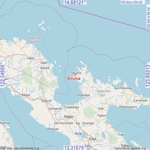
Siruma GPS coordinates[2]
14° 0' 0" North, 123° 15' 0" East
| Map corner | latitude | longitude |
|---|---|---|
| Upper-left | 14.68121°, | 122.54688° |
| Center: | 14°, | 123.25° |
| Lower-right: | 13.31676°, | 123.95313° |
| Map W x H: | 151.7×151.7 km | = 94.3×94.3mi |
| max Lat: | 20.78733° ⇑30.9% North |
| Siruma: | 14° |
| min Lat: | ⇓69.1% South 4.65442° |
| min Long | Siruma | max Long |
| 117.04868° | 123.25° | 126.58417° |
| W 57.4%⇐ | ⇒42.6% E |
Elevation
Elevation of Siruma is 10 m = 33 ft, and this is 77.9 m = 256 ft below average elevation for this country.
| Max E: |
2262 m = 7421 ft | 76.6% |
| Avg. | 87.9 m = 288 ft | |
| Siruma | 10 m = 33 ft | |
Min E: |
-2 m = -7 ft | 23.4% |
See also: Philippines elevation on elevation.city.
Geographical zone
Siruma is located in North Torrid zone (between Equator and Tropic of Cancer). Distance of this Northern Tropic circle is 1049.3 km =652 mi to North.| Distance of | km | miles | from Siruma |
|---|---|---|---|
| North Pole | 8450.4 | 5250.8 | to North |
| Arctic Circle | 5844.5 | 3631.6 | to North |
| Tropic Cancer | 1049.3 | 652 | to North |
| Equator | 1556.7 | 967.3 | to South |


Nearby cities:
15 places around Siruma: (largest is in red/bold)
• Bagacay
25.5 km =15.8 mi,  166°
166°
• Barcelona
33.4 km =20.8 mi,  220°
220°
• Basud
31.7 km =19.7 mi,  283°
283°
• Binanwanaan
33.8 km =21 mi, 170°
• Buenavista
15.8 km =9.8 mi,  159°
159°
• Calabanga
32.9 km =20.4 mi,  187°
187°
• Castillo
33.2 km =20.6 mi,  205°
205°
• Kaliliog
11.6 km =7.2 mi, 156°
• Manquiring
29.6 km =18.4 mi,  176°
176°
• Mercedes
28.5 km =17.7 mi,  295°
295°
• Pambuhan
18.2 km =11.3 mi,  260°
260°
• Paulba
31.8 km =19.8 mi, 180°
• San Lucas
33.1 km =20.6 mi, 188°
• Sogod
19.9 km =12.4 mi, 158°
• Tinambac
22 km =13.7 mi, 158°
Sources, notices
• [Note1] Compared only with cities in Philippines existing in our database
• [Src1] Map data: © OpenStreetMap contributors (CC-BY-SA)
• [Src2] Other city data from geonames.org with taken over terms of usage.
• [Src3] Geographical zone / Annual Mean Temperature by Robert A. Rohde @ Wikipedia
