Mampurog geodata
Mampurog (Bicol) is a populated place; located in Philippines in Asia/Manila (GMT+8) time zone. With population of 2,310 people, there are 3654 cities with bigger population in this country. Compared to other cities in Philippines, 69.8% of cities are located further ↓South; 51.3% of cities are located further ←West and 83.4% of cities have lower elevation than Mampurog. Note1
Administrative division(s):
- Level 1: Bicol
- Level 2: Province of Camarines Norte
- Level 3: San Lorenzo Ruiz (Imelda)


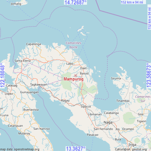
Mampurog GPS coordinates[2]
14° 2' 44.88" North, 122° 53' 0.96" East
| Map corner | latitude | longitude |
|---|---|---|
| Upper-left | 14.72687°, | 122.18048° |
| Center: | 14.0458°, | 122.8836° |
| Lower-right: | 13.3627°, | 123.58673° |
| Map W x H: | 151.7×151.7 km | = 94.3×94.3mi |
| max Lat: | 20.78733° ⇑30.2% North |
| Mampurog: | 14.0458° |
| min Lat: | ⇓69.8% South 4.65442° |
| min Long | Mampurog | max Long |
| 117.04868° | 122.8836° | 126.58417° |
| W 51.3%⇐ | ⇒48.7% E |
Elevation
Elevation of Mampurog is 119 m = 390 ft, and this is 31.1 m = 102 ft above average elevation for this country.
| Max E: |
2262 m = 7421 ft | 16.6% |
| Mampurog | 119 m 390 ft | |
| Avg. | 87.9 m = 288 ft | |
Min E: |
-2 m = -7 ft | 83.4% |
See also: Philippines elevation on elevation.city.
Geographical zone
Mampurog is located in North Torrid zone (between Equator and Tropic of Cancer). Distance of this Northern Tropic circle is 1044.2 km =648.8 mi to North.| Distance of | km | miles | from Mampurog |
|---|---|---|---|
| North Pole | 8445.3 | 5247.7 | to North |
| Arctic Circle | 5839.4 | 3628.4 | to North |
| Tropic Cancer | 1044.2 | 648.8 | to North |
| Equator | 1561.7 | 970.4 | to South |


Nearby cities:
15 places around Mampurog: (largest is in red/bold)
• Basud
9 km =5.6 mi,  76°
76°
• Calasgasan
6.8 km =4.2 mi,  52°
52°
• Daet
10.7 km =6.6 mi, 46°
• Dugongan
6.8 km =4.2 mi,  21°
21°
• Guinacotan
12.5 km =7.8 mi,  352°
352°
• Imelda
1.4 km =0.9 mi,  181°
181°
• Labo
13.3 km =8.3 mi,  334°
334°
• Lugui
12.3 km =7.6 mi,  307°
307°
• Malasugui
11.6 km =7.2 mi,  340°
340°
• Matnog
5.8 km =3.6 mi,  66°
66°
• San Felipe
5.8 km =3.6 mi,  121°
121°
• San Vicente
6.8 km =4.2 mi, 350°
• Santo Domingo
9.8 km =6.1 mi,  2°
2°
• Talisay
10.7 km =6.6 mi, 23°
• Tulay na Lupa
11.8 km =7.3 mi,  296°
296°
Sources, notices
• [Note1] Compared only with cities in Philippines existing in our database
• [Src1] Map data: © OpenStreetMap contributors (CC-BY-SA)
• [Src2] Other city data from geonames.org with taken over terms of usage.
• [Src3] Geographical zone / Annual Mean Temperature by Robert A. Rohde @ Wikipedia
