Palaroo geodata
Palaroo (Eastern Visayas) is a populated place; located in Philippines in Asia/Manila (GMT+8) time zone. With population of 2,409 people, there are 3444 cities with bigger population in this country. Compared to other cities in Philippines, 52.5% of cities are located further ↑North; 78.7% of cities are located further ←West and 52.3% of cities have lower elevation than Palaroo. Note1


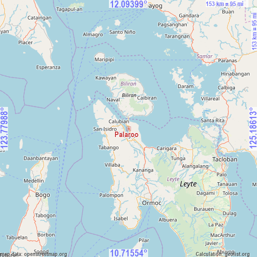
Palaroo GPS coordinates[2]
11° 24' 20.16" North, 124° 28' 58.8" East
| Map corner | latitude | longitude |
|---|---|---|
| Upper-left | 12.09399°, | 123.77988° |
| Center: | 11.4056°, | 124.483° |
| Lower-right: | 10.71554°, | 125.18613° |
| Map W x H: | 153.3×153.3 km | = 95.3×95.3mi |
| max Lat: | 20.78733° ⇑52.5% North |
| Palaroo: | 11.4056° |
| min Lat: | ⇓47.5% South 4.65442° |
| min Long | Palaroo | max Long |
| 117.04868° | 124.483° | 126.58417° |
| W 78.7%⇐ | ⇒21.3% E |
Elevation
Elevation of Palaroo is 25 m = 82 ft, and this is 62.9 m = 206 ft below average elevation for this country.
| Max E: |
2262 m = 7421 ft | 47.7% |
| Avg. | 87.9 m = 288 ft | |
| Palaroo | 25 m = 82 ft | |
Min E: |
-2 m = -7 ft | 52.3% |
See also: Philippines elevation on elevation.city.
Geographical zone
Palaroo is located in North Torrid zone (between Equator and Tropic of Cancer). Distance of Equator is 1268.2 km =788 mi to South.| Distance of | km | miles | from Palaroo |
|---|---|---|---|
| North Pole | 8738.9 | 5430.1 | to North |
| Arctic Circle | 6133 | 3810.9 | to North |
| Tropic Cancer | 1337.7 | 831.2 | to North |
| Equator | 1268.2 | 788 | to South |


Nearby cities:
15 places around Palaroo: (largest is in red/bold)
• Balagui
9.4 km =5.8 mi,  34°
34°
• Basud
13.8 km =8.6 mi,  251°
251°
• Biliran
6.9 km =4.3 mi,  351°
351°
• Bunga
14.7 km =9.1 mi,  53°
53°
• Butazon
11.2 km =7 mi,  191°
191°
• Cabucgayan
12.4 km =7.7 mi, 53°
• Calubian
7.6 km =4.7 mi,  307°
307°
• Consuegra
12.4 km =7.7 mi,  165°
165°
• Kampokpok
14.8 km =9.2 mi,  214°
214°
• Leyte
4.3 km =2.7 mi,  180°
180°
• Looc
11.2 km =7 mi,  43°
43°
• Pinamopoan
14.2 km =8.8 mi,  135°
135°
• San Isidro
14.3 km =8.9 mi,  270°
270°
• Tabing
14.5 km =9 mi, 267°
• Umaganhan
14.3 km =8.9 mi,  233°
233°
Sources, notices
• [Note1] Compared only with cities in Philippines existing in our database
• [Src1] Map data: © OpenStreetMap contributors (CC-BY-SA)
• [Src2] Other city data from geonames.org with taken over terms of usage.
• [Src3] Geographical zone / Annual Mean Temperature by Robert A. Rohde @ Wikipedia
