Biliran geodata
Biliran (Eastern Visayas) is a seat of a third-order administrative division; located in Philippines in Asia/Manila (GMT+8) time zone. With population of 4,699 people, there are 1413 cities with bigger population in this country. Compared to other cities in Philippines, 51.8% of cities are located further ↑North; 78.6% of cities are located further ←West and 92.7% of cities have higher elevation than Biliran. Note1


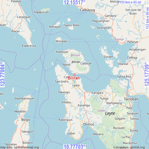
Biliran GPS coordinates[2]
11° 28' 0.984" North, 124° 28' 26.256" East
| Map corner | latitude | longitude |
|---|---|---|
| Upper-left | 12.15517°, | 123.77084° |
| Center: | 11.46694°, | 124.47396° |
| Lower-right: | 10.77703°, | 125.17709° |
| Map W x H: | 153.2×153.2 km | = 95.2×95.2mi |
| max Lat: | 20.78733° ⇑51.8% North |
| Biliran: | 11.46694° |
| min Lat: | ⇓48.2% South 4.65442° |
| min Long | Biliran | max Long |
| 117.04868° | 124.47396° | 126.58417° |
| W 78.6%⇐ | ⇒21.4% E |
Elevation
Elevation of Biliran is 6 m = 20 ft, and this is 81.9 m = 269 ft below average elevation for this country.
| Max E: |
2262 m = 7421 ft | 92.7% |
| Avg. | 87.9 m = 288 ft | |
| Biliran | 6 m = 20 ft | |
Min E: |
-2 m = -7 ft | 7.3% |
See also: Philippines elevation on elevation.city.
Geographical zone
Biliran is located in North Torrid zone (between Equator and Tropic of Cancer). Distance of Equator is 1275 km =792.2 mi to South.| Distance of | km | miles | from Biliran |
|---|---|---|---|
| North Pole | 8732.1 | 5425.9 | to North |
| Arctic Circle | 6126.2 | 3806.6 | to North |
| Tropic Cancer | 1330.9 | 827 | to North |
| Equator | 1275 | 792.2 | to South |


Nearby cities:
15 places around Biliran: (largest is in red/bold)
• Balagui
6.4 km =4 mi,  81°
81°
• Basud
16.5 km =10.3 mi,  227°
227°
• Bunga
13 km =8.1 mi, 81°
• Butazon
17.8 km =11.1 mi,  184°
184°
• Cabucgayan
11 km =6.8 mi,  87°
87°
• Caibiran
16.6 km =10.3 mi,  45°
45°
• Calubian
5.5 km =3.4 mi,  246°
246°
• Caraycaray
11.7 km =7.3 mi,  326°
326°
• Catmon
8.9 km =5.5 mi, 328°
• Leyte
11.2 km =7 mi, 175°
• Looc
8.8 km =5.5 mi, 81°
• Naval
13.3 km =8.3 mi,  321°
321°
• Palaroo
6.9 km =4.3 mi,  171°
171°
• San Isidro
14.9 km =9.3 mi,  243°
243°
• Tabing
15.4 km =9.6 mi, 241°
In other languages:
- In Spanish: Provincia de Bilirán
- In Italian: Provincia di Biliran
- In Russian: Билиран
- In Chinese: 比利兰省
Sources, notices
• [Note1] Compared only with cities in Philippines existing in our database
• [Src1] Map data: © OpenStreetMap contributors (CC-BY-SA)
• [Src2] Other city data from geonames.org with taken over terms of usage.
• [Src3] Geographical zone / Annual Mean Temperature by Robert A. Rohde @ Wikipedia
