Orion geodata
Orion (Central Luzon) is a seat of a third-order administrative division; located in Philippines in Asia/Manila (GMT+8) time zone. With population of 46,991 people, there are 188 cities with bigger population in this country. Compared to other cities in Philippines, 74.7% of cities are located further ↓South; 88.8% of cities are located further →East and 80.7% of cities have higher elevation than Orion. Note1


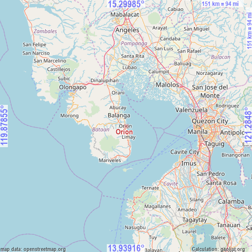
Orion GPS coordinates[2]
14° 37' 14.016" North, 120° 34' 54.012" East
| Map corner | latitude | longitude |
|---|---|---|
| Upper-left | 15.29985°, | 119.87855° |
| Center: | 14.62056°, | 120.58167° |
| Lower-right: | 13.93916°, | 121.2848° |
| Map W x H: | 151.3×151.3 km | = 94×94mi |
| max Lat: | 20.78733° ⇑25.3% North |
| Orion: | 14.62056° |
| min Lat: | ⇓74.7% South 4.65442° |
| min Long | Orion | max Long |
| 117.04868° | 120.58167° | 126.58417° |
| W 11.2%⇐ | ⇒88.8% E |
Elevation
Elevation of Orion is 9 m = 30 ft, and this is 78.9 m = 259 ft below average elevation for this country.
| Max E: |
2262 m = 7421 ft | 80.7% |
| Avg. | 87.9 m = 288 ft | |
| Orion | 9 m = 30 ft | |
Min E: |
-2 m = -7 ft | 19.3% |
See also: Orion elevation on elevation.city.
Geographical zone
Orion is located in North Torrid zone (between Equator and Tropic of Cancer). Distance of this Northern Tropic circle is 980.3 km =609.1 mi to North.| Distance of | km | miles | from Orion |
|---|---|---|---|
| North Pole | 8381.4 | 5208 | to North |
| Arctic Circle | 5775.5 | 3588.7 | to North |
| Tropic Cancer | 980.3 | 609.1 | to North |
| Equator | 1625.7 | 1010.2 | to South |


Nearby cities:
15 places around Orion: (largest is in red/bold)
• Abucay
13.6 km =8.5 mi,  337°
337°
• Bagac
20.5 km =12.7 mi,  262°
262°
• Balanga
7.9 km =4.9 mi,  321°
321°
• Balut
7.8 km =4.8 mi,  333°
333°
• Banawang
20.6 km =12.8 mi,  267°
267°
• Cabcaben
18.5 km =11.5 mi,  176°
176°
• Camachile
2.6 km =1.6 mi,  357°
357°
• Hermosa
24.7 km =15.3 mi, 341°
• Limay
6.8 km =4.2 mi,  164°
164°
• Mariveles
23.2 km =14.4 mi,  206°
206°
• Orani
20.6 km =12.8 mi,  346°
346°
• Parang
14.3 km =8.9 mi,  275°
275°
• Pilar
4.7 km =2.9 mi, 338°
• Samal
16.9 km =10.5 mi, 345°
• Saysain
21.4 km =13.3 mi,  252°
252°
Sources, notices
• [Note1] Compared only with cities in Philippines existing in our database
• [Src1] Map data: © OpenStreetMap contributors (CC-BY-SA)
• [Src2] Other city data from geonames.org with taken over terms of usage.
• [Src3] Geographical zone / Annual Mean Temperature by Robert A. Rohde @ Wikipedia
