Cabcaben geodata
Cabcaben (Central Luzon) is a populated place; located in Philippines in Asia/Manila (GMT+8) time zone. With population of 5,949 people, there are 1061 cities with bigger population in this country. Compared to other cities in Philippines, 73.9% of cities are located further ↓South; 88.4% of cities are located further →East and 80.7% of cities have higher elevation than Cabcaben. Note1


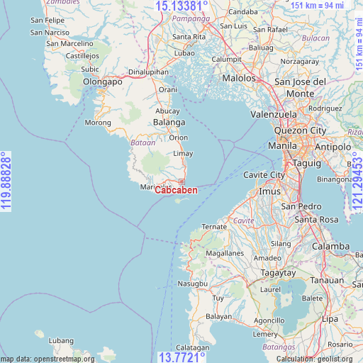
Cabcaben GPS coordinates[2]
14° 27' 14.4" North, 120° 35' 29.04" East
| Map corner | latitude | longitude |
|---|---|---|
| Upper-left | 15.13381°, | 119.88828° |
| Center: | 14.454°, | 120.5914° |
| Lower-right: | 13.7721°, | 121.29453° |
| Map W x H: | 151.4×151.4 km | = 94.1×94.1mi |
| max Lat: | 20.78733° ⇑26.1% North |
| Cabcaben: | 14.454° |
| min Lat: | ⇓73.9% South 4.65442° |
| min Long | Cabcaben | max Long |
| 117.04868° | 120.5914° | 126.58417° |
| W 11.6%⇐ | ⇒88.4% E |
Elevation
Elevation of Cabcaben is 9 m = 30 ft, and this is 78.9 m = 259 ft below average elevation for this country.
| Max E: |
2262 m = 7421 ft | 80.7% |
| Avg. | 87.9 m = 288 ft | |
| Cabcaben | 9 m = 30 ft | |
Min E: |
-2 m = -7 ft | 19.3% |
See also: Philippines elevation on elevation.city.
Geographical zone
Cabcaben is located in North Torrid zone (between Equator and Tropic of Cancer). Distance of this Northern Tropic circle is 998.8 km =620.6 mi to North.| Distance of | km | miles | from Cabcaben |
|---|---|---|---|
| North Pole | 8399.9 | 5219.5 | to North |
| Arctic Circle | 5794 | 3600.2 | to North |
| Tropic Cancer | 998.8 | 620.6 | to North |
| Equator | 1607.1 | 998.6 | to South |


Nearby cities:
15 places around Cabcaben: (largest is in red/bold)
• Bagac
26.6 km =16.5 mi,  306°
306°
• Balanga
25.4 km =15.8 mi,  346°
346°
• Balut
25.9 km =16.1 mi, 350°
• Banawang
27.9 km =17.3 mi, 309°
• Camachile
21.1 km =13.1 mi,  356°
356°
• Halayhay
25.5 km =15.8 mi,  110°
110°
• Limay
12 km =7.5 mi,  3°
3°
• Maragondon
25.5 km =15.8 mi,  141°
141°
• Mariveles
11.6 km =7.2 mi,  258°
258°
• Naic
24.1 km =15 mi,  128°
128°
• Orion
18.5 km =11.5 mi, 356°
• Parang
25.1 km =15.6 mi,  322°
322°
• Pilar
23.1 km =14.4 mi, 353°
• Saysain
24.5 km =15.2 mi,  299°
299°
• Ternate
22.7 km =14.1 mi, 143°
Sources, notices
• [Note1] Compared only with cities in Philippines existing in our database
• [Src1] Map data: © OpenStreetMap contributors (CC-BY-SA)
• [Src2] Other city data from geonames.org with taken over terms of usage.
• [Src3] Geographical zone / Annual Mean Temperature by Robert A. Rohde @ Wikipedia
