Camachile geodata
Camachile (Central Luzon) is a populated place; located in Philippines in Asia/Manila (GMT+8) time zone. With population of 2,767 people, there are 2847 cities with bigger population in this country. Compared to other cities in Philippines, 74.8% of cities are located further ↓South; 88.8% of cities are located further →East and 97.1% of cities have higher elevation than Camachile. Note1


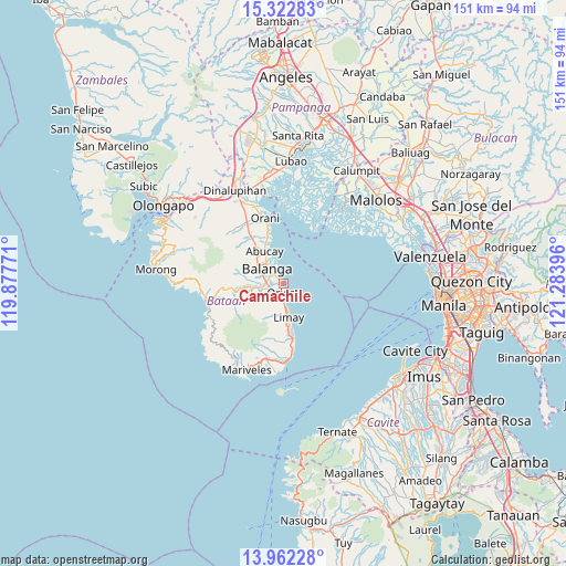
Camachile GPS coordinates[2]
14° 38' 36.996" North, 120° 34' 50.988" East
| Map corner | latitude | longitude |
|---|---|---|
| Upper-left | 15.32283°, | 119.87771° |
| Center: | 14.64361°, | 120.58083° |
| Lower-right: | 13.96228°, | 121.28396° |
| Map W x H: | 151.3×151.3 km | = 94×94mi |
| max Lat: | 20.78733° ⇑25.2% North |
| Camachile: | 14.64361° |
| min Lat: | ⇓74.8% South 4.65442° |
| min Long | Camachile | max Long |
| 117.04868° | 120.58083° | 126.58417° |
| W 11.2%⇐ | ⇒88.8% E |
Elevation
Elevation of Camachile is 4 m = 13 ft, and this is 83.9 m = 275 ft below average elevation for this country.
| Max E: |
2262 m = 7421 ft | 97.1% |
| Avg. | 87.9 m = 288 ft | |
| Camachile | 4 m = 13 ft | |
Min E: |
-2 m = -7 ft | 2.9% |
See also: Philippines elevation on elevation.city.
Geographical zone
Camachile is located in North Torrid zone (between Equator and Tropic of Cancer). Distance of this Northern Tropic circle is 977.7 km =607.5 mi to North.| Distance of | km | miles | from Camachile |
|---|---|---|---|
| North Pole | 8378.8 | 5206.3 | to North |
| Arctic Circle | 5773 | 3587.2 | to North |
| Tropic Cancer | 977.7 | 607.5 | to North |
| Equator | 1628.2 | 1011.7 | to South |


Nearby cities:
15 places around Camachile: (largest is in red/bold)
• Abucay
11.2 km =7 mi,  333°
333°
• Bagac
20.9 km =13 mi,  255°
255°
• Balanga
6 km =3.7 mi,  306°
306°
• Balut
5.5 km =3.4 mi,  323°
323°
• Banawang
20.8 km =12.9 mi, 260°
• Cabcaben
21.1 km =13.1 mi,  176°
176°
• Hermosa
22.3 km =13.9 mi,  339°
339°
• Limay
9.3 km =5.8 mi,  168°
168°
• Malusac
24.3 km =15.1 mi,  10°
10°
• Orani
18.1 km =11.2 mi, 344°
• Orion
2.6 km =1.6 mi, 177°
• Parang
14.2 km =8.8 mi,  265°
265°
• Pilar
2.5 km =1.6 mi, 317°
• Samal
14.4 km =8.9 mi, 343°
• Saysain
22.2 km =13.8 mi,  245°
245°
Sources, notices
• [Note1] Compared only with cities in Philippines existing in our database
• [Src1] Map data: © OpenStreetMap contributors (CC-BY-SA)
• [Src2] Other city data from geonames.org with taken over terms of usage.
• [Src3] Geographical zone / Annual Mean Temperature by Robert A. Rohde @ Wikipedia
