Banawang geodata
Banawang (Central Luzon) is a populated place; located in Philippines in Asia/Manila (GMT+8) time zone. With population of 2,306 people, there are 3668 cities with bigger population in this country. Compared to other cities in Philippines, 74.7% of cities are located further ↓South; 94.1% of cities are located further →East and 52.3% of cities have lower elevation than Banawang. Note1


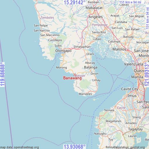
Banawang GPS coordinates[2]
14° 36' 43.56" North, 120° 23' 24" East
| Map corner | latitude | longitude |
|---|---|---|
| Upper-left | 15.29142°, | 119.68688° |
| Center: | 14.6121°, | 120.39° |
| Lower-right: | 13.93068°, | 121.09313° |
| Map W x H: | 151.3×151.3 km | = 94×94mi |
| max Lat: | 20.78733° ⇑25.3% North |
| Banawang: | 14.6121° |
| min Lat: | ⇓74.7% South 4.65442° |
| min Long | Banawang | max Long |
| 117.04868° | 120.39° | 126.58417° |
| W 5.9%⇐ | ⇒94.1% E |
Elevation
Elevation of Banawang is 25 m = 82 ft, and this is 62.9 m = 206 ft below average elevation for this country.
| Max E: |
2262 m = 7421 ft | 47.7% |
| Avg. | 87.9 m = 288 ft | |
| Banawang | 25 m = 82 ft | |
Min E: |
-2 m = -7 ft | 52.3% |
See also: Philippines elevation on elevation.city.
Geographical zone
Banawang is located in North Torrid zone (between Equator and Tropic of Cancer). Distance of this Northern Tropic circle is 981.2 km =609.7 mi to North.| Distance of | km | miles | from Banawang |
|---|---|---|---|
| North Pole | 8382.3 | 5208.5 | to North |
| Arctic Circle | 5776.5 | 3589.3 | to North |
| Tropic Cancer | 981.2 | 609.7 | to North |
| Equator | 1624.7 | 1009.5 | to South |


Nearby cities:
15 places around Banawang: (largest is in red/bold)
• Abucay
20.5 km =12.7 mi,  48°
48°
• Bagac
1.8 km =1.1 mi,  170°
170°
• Balanga
17.3 km =10.7 mi,  65°
65°
• Balut
18.9 km =11.7 mi, 65°
• Camachile
20.8 km =12.9 mi,  80°
80°
• Limay
23.1 km =14.4 mi,  103°
103°
• Mabayo
17.9 km =11.1 mi,  317°
317°
• Mariveles
22.3 km =13.9 mi,  152°
152°
• Morong
15.3 km =9.5 mi,  299°
299°
• Orion
20.6 km =12.8 mi,  87°
87°
• Parang
6.8 km =4.2 mi, 69°
• Pilar
19.6 km =12.2 mi, 74°
• Sabang
17.6 km =10.9 mi, 301°
• Saysain
5.7 km =3.5 mi,  177°
177°
• Subic Bay Freeport Zone
23 km =14.3 mi,  328°
328°
Sources, notices
• [Note1] Compared only with cities in Philippines existing in our database
• [Src1] Map data: © OpenStreetMap contributors (CC-BY-SA)
• [Src2] Other city data from geonames.org with taken over terms of usage.
• [Src3] Geographical zone / Annual Mean Temperature by Robert A. Rohde @ Wikipedia
