Nancalobasaan geodata
Nancalobasaan (Ilocos) is a populated place; located in Philippines in Asia/Manila (GMT+8) time zone. With population of 2,139 people, there are 4013 cities with bigger population in this country. Compared to other cities in Philippines, 86.5% of cities are located further ↓South; 81.2% of cities are located further →East and 82.3% of cities have lower elevation than Nancalobasaan. Note1


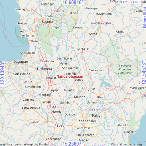
Nancalobasaan GPS coordinates[2]
15° 56' 3.12" North, 120° 50' 33.36" East
| Map corner | latitude | longitude |
|---|---|---|
| Upper-left | 16.60916°, | 120.13948° |
| Center: | 15.9342°, | 120.8426° |
| Lower-right: | 15.25697°, | 121.54573° |
| Map W x H: | 150.3×150.4 km | = 93.4×93.5mi |
| max Lat: | 20.78733° ⇑13.5% North |
| Nancalobasaan: | 15.9342° |
| min Lat: | ⇓86.5% South 4.65442° |
| min Long | Nancalobasaan | max Long |
| 117.04868° | 120.8426° | 126.58417° |
| W 18.8%⇐ | ⇒81.2% E |
Elevation
Elevation of Nancalobasaan is 109 m = 358 ft, and this is 21.1 m = 69 ft above average elevation for this country.
| Max E: |
2262 m = 7421 ft | 17.7% |
| Nancalobasaan | 109 m 358 ft | |
| Avg. | 87.9 m = 288 ft | |
Min E: |
-2 m = -7 ft | 82.3% |
See also: Philippines elevation on elevation.city.
Geographical zone
Nancalobasaan is located in North Torrid zone (between Equator and Tropic of Cancer). Distance of this Northern Tropic circle is 834.2 km =518.3 mi to North.| Distance of | km | miles | from Nancalobasaan |
|---|---|---|---|
| North Pole | 8235.3 | 5117.2 | to North |
| Arctic Circle | 5629.5 | 3498 | to North |
| Tropic Cancer | 834.2 | 518.3 | to North |
| Equator | 1771.7 | 1100.9 | to South |


Nearby cities:
15 places around Nancalobasaan: (largest is in red/bold)
• Alac
7.1 km =4.4 mi,  327°
327°
• Cabalaoangan
8.4 km =5.2 mi,  310°
310°
• Carriedo
14.3 km =8.9 mi,  318°
318°
• Diaz
9.8 km =6.1 mi,  184°
184°
• Digdig
14.5 km =9 mi,  83°
83°
• Lagasit
8.4 km =5.2 mi, 321°
• Lupao
8.5 km =5.3 mi,  135°
135°
• Magallanes
14.6 km =9.1 mi, 310°
• Natividad
13.1 km =8.1 mi,  339°
339°
• Panganiban
10.9 km =6.8 mi, 318°
• Parista
12.8 km =8 mi,  134°
134°
• Salvacion I
13.1 km =8.1 mi, 143°
• Sampaloc
13.3 km =8.3 mi,  168°
168°
• San Quintin
6.5 km =4 mi, 331°
• Umingan
6.1 km =3.8 mi,  231°
231°
Sources, notices
• [Note1] Compared only with cities in Philippines existing in our database
• [Src1] Map data: © OpenStreetMap contributors (CC-BY-SA)
• [Src2] Other city data from geonames.org with taken over terms of usage.
• [Src3] Geographical zone / Annual Mean Temperature by Robert A. Rohde @ Wikipedia
