Maxingal geodata
Maxingal (Cagayan Valley) is a populated place; located in Philippines in Asia/Manila (GMT+8) time zone. With population of 2,323 people, there are 3624 cities with bigger population in this country. Compared to other cities in Philippines, 98.9% of cities are located further ↓South; 64.5% of cities are located further →East and 92.7% of cities have higher elevation than Maxingal. Note1


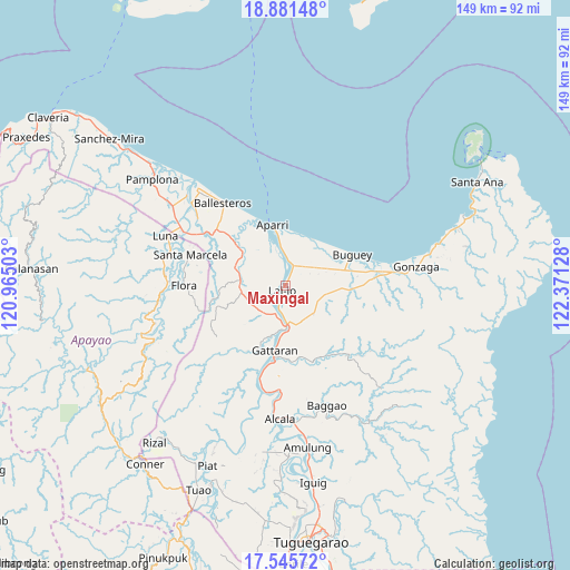
Maxingal GPS coordinates[2]
18° 12' 53.568" North, 121° 40' 5.34" East
| Map corner | latitude | longitude |
|---|---|---|
| Upper-left | 18.88148°, | 120.96503° |
| Center: | 18.21488°, | 121.66815° |
| Lower-right: | 17.54572°, | 122.37128° |
| Map W x H: | 148.5×148.5 km | = 92.3×92.3mi |
| max Lat: | 20.78733° ⇑1.1% North |
| Maxingal: | 18.21488° |
| min Lat: | ⇓98.9% South 4.65442° |
| min Long | Maxingal | max Long |
| 117.04868° | 121.66815° | 126.58417° |
| W 35.5%⇐ | ⇒64.5% E |
Elevation
Elevation of Maxingal is 6 m = 20 ft, and this is 81.9 m = 269 ft below average elevation for this country.
| Max E: |
2262 m = 7421 ft | 92.7% |
| Avg. | 87.9 m = 288 ft | |
| Maxingal | 6 m = 20 ft | |
Min E: |
-2 m = -7 ft | 7.3% |
See also: Philippines elevation on elevation.city.
Geographical zone
Maxingal is located in North Torrid zone (between Equator and Tropic of Cancer). Distance of this Northern Tropic circle is 580.6 km =360.8 mi to North.| Distance of | km | miles | from Maxingal |
|---|---|---|---|
| North Pole | 7981.8 | 4959.7 | to North |
| Arctic Circle | 5375.9 | 3340.4 | to North |
| Tropic Cancer | 580.6 | 360.8 | to North |
| Equator | 2025.3 | 1258.5 | to South |


Nearby cities:
15 places around Maxingal: (largest is in red/bold)
• Allacapan
11.9 km =7.4 mi,  275°
275°
• Aparri
16 km =9.9 mi,  349°
349°
• Bagumbayan
2.4 km =1.5 mi,  193°
193°
• Binalan
18 km =11.2 mi,  313°
313°
• Buguey
19.2 km =11.9 mi,  64°
64°
• Camalaniugan
6.6 km =4.1 mi,  6°
6°
• Catayauan
6.2 km =3.9 mi,  195°
195°
• Gattaran
17.2 km =10.7 mi, 188°
• Lasam
18.1 km =11.2 mi, 203°
• Magapit
8.6 km =5.3 mi,  179°
179°
• Magapit, Aguiguican
11.9 km =7.4 mi, 175°
• Paddaya
14.2 km =8.8 mi,  31°
31°
• Paddaya
15.1 km =9.4 mi,  43°
43°
• Pattao
15.9 km =9.9 mi,  77°
77°
• Santa Maria
8.2 km =5.1 mi, 182°
Sources, notices
• [Note1] Compared only with cities in Philippines existing in our database
• [Src1] Map data: © OpenStreetMap contributors (CC-BY-SA)
• [Src2] Other city data from geonames.org with taken over terms of usage.
• [Src3] Geographical zone / Annual Mean Temperature by Robert A. Rohde @ Wikipedia
