Magapit geodata
Magapit (Cagayan Valley) is a populated place; located in Philippines in Asia/Manila (GMT+8) time zone. With population of 11,235 people, there are 547 cities with bigger population in this country. Compared to other cities in Philippines, 98.7% of cities are located further ↓South; 64.5% of cities are located further →East and 80.7% of cities have higher elevation than Magapit. Note1


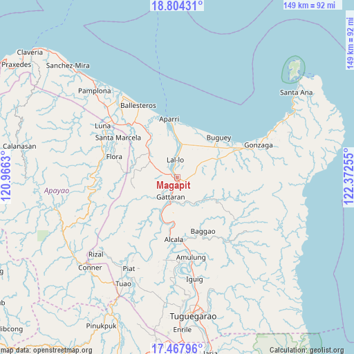
Magapit GPS coordinates[2]
18° 8' 14.676" North, 121° 40' 9.912" East
| Map corner | latitude | longitude |
|---|---|---|
| Upper-left | 18.80431°, | 120.9663° |
| Center: | 18.13741°, | 121.66942° |
| Lower-right: | 17.46796°, | 122.37255° |
| Map W x H: | 148.6×148.6 km | = 92.3×92.3mi |
| max Lat: | 20.78733° ⇑1.3% North |
| Magapit: | 18.13741° |
| min Lat: | ⇓98.7% South 4.65442° |
| min Long | Magapit | max Long |
| 117.04868° | 121.66942° | 126.58417° |
| W 35.5%⇐ | ⇒64.5% E |
Elevation
Elevation of Magapit is 9 m = 30 ft, and this is 78.9 m = 259 ft below average elevation for this country.
| Max E: |
2262 m = 7421 ft | 80.7% |
| Avg. | 87.9 m = 288 ft | |
| Magapit | 9 m = 30 ft | |
Min E: |
-2 m = -7 ft | 19.3% |
See also: Philippines elevation on elevation.city.
Geographical zone
Magapit is located in North Torrid zone (between Equator and Tropic of Cancer). Distance of this Northern Tropic circle is 589.2 km =366.1 mi to North.| Distance of | km | miles | from Magapit |
|---|---|---|---|
| North Pole | 7990.4 | 4965 | to North |
| Arctic Circle | 5384.5 | 3345.8 | to North |
| Tropic Cancer | 589.2 | 366.1 | to North |
| Equator | 2016.7 | 1253.1 | to South |


Nearby cities:
15 places around Magapit: (largest is in red/bold)
• Alannay
12.2 km =7.6 mi,  226°
226°
• Allacapan
15.5 km =9.6 mi,  309°
309°
• Bagumbayan
6.3 km =3.9 mi,  353°
353°
• Calaoagan
12 km =7.5 mi,  151°
151°
• Camalaniugan
15.2 km =9.4 mi,  2°
2°
• Capissayan Sur
18.4 km =11.4 mi,  121°
121°
• Catayauan
3.1 km =1.9 mi,  325°
325°
• Gattaran
8.8 km =5.5 mi,  197°
197°
• Lasam
10.8 km =6.7 mi,  222°
222°
• Magapit, Aguiguican
3.4 km =2.1 mi,  166°
166°
• Maxingal
8.6 km =5.3 mi,  359°
359°
• Nabannagan West
15.9 km =9.9 mi,  242°
242°
• Palagao Norte
11.6 km =7.2 mi, 153°
• Pattao
19.6 km =12.2 mi,  51°
51°
• Santa Maria
0.7 km =0.4 mi, 311°
Sources, notices
• [Note1] Compared only with cities in Philippines existing in our database
• [Src1] Map data: © OpenStreetMap contributors (CC-BY-SA)
• [Src2] Other city data from geonames.org with taken over terms of usage.
• [Src3] Geographical zone / Annual Mean Temperature by Robert A. Rohde @ Wikipedia
