Allacapan geodata
Allacapan (Cagayan Valley) is a seat of a third-order administrative division; located in Philippines in Asia/Manila (GMT+8) time zone. With population of 3,645 people, there are 1949 cities with bigger population in this country. Compared to other cities in Philippines, 99% of cities are located further ↓South; 65.8% of cities are located further →East and 85.4% of cities have higher elevation than Allacapan. Note1


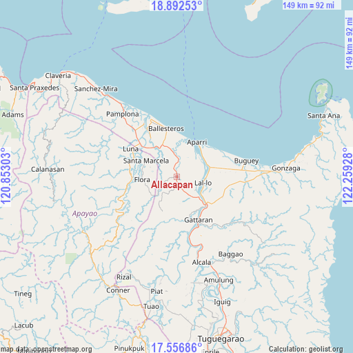
Allacapan GPS coordinates[2]
18° 13' 33.528" North, 121° 33' 22.14" East
| Map corner | latitude | longitude |
|---|---|---|
| Upper-left | 18.89253°, | 120.85303° |
| Center: | 18.22598°, | 121.55615° |
| Lower-right: | 17.55686°, | 122.25928° |
| Map W x H: | 148.5×148.5 km | = 92.3×92.3mi |
| max Lat: | 20.78733° ⇑1% North |
| Allacapan: | 18.22598° |
| min Lat: | ⇓99% South 4.65442° |
| min Long | Allacapan | max Long |
| 117.04868° | 121.55615° | 126.58417° |
| W 34.2%⇐ | ⇒65.8% E |
Elevation
Elevation of Allacapan is 8 m = 26 ft, and this is 79.9 m = 262 ft below average elevation for this country.
| Max E: |
2262 m = 7421 ft | 85.4% |
| Avg. | 87.9 m = 288 ft | |
| Allacapan | 8 m = 26 ft | |
Min E: |
-2 m = -7 ft | 14.6% |
See also: Philippines elevation on elevation.city.
Geographical zone
Allacapan is located in North Torrid zone (between Equator and Tropic of Cancer). Distance of this Northern Tropic circle is 579.4 km =360 mi to North.| Distance of | km | miles | from Allacapan |
|---|---|---|---|
| North Pole | 7980.5 | 4958.9 | to North |
| Arctic Circle | 5374.6 | 3339.6 | to North |
| Tropic Cancer | 579.4 | 360 | to North |
| Equator | 2026.5 | 1259.2 | to South |


Nearby cities:
15 places around Allacapan: (largest is in red/bold)
• Aparri
17 km =10.6 mi,  31°
31°
• Bagumbayan
11.8 km =7.3 mi,  107°
107°
• Binalan
11.3 km =7 mi,  354°
354°
• Camalaniugan
13.6 km =8.5 mi,  66°
66°
• Catayauan
12.5 km =7.8 mi,  125°
125°
• Flora
14.6 km =9.1 mi,  265°
265°
• Guiddam
15.4 km =9.6 mi,  321°
321°
• Lucban
18.1 km =11.2 mi,  312°
312°
• Mabuttal East
17.3 km =10.7 mi, 345°
• Magapit
15.5 km =9.6 mi, 129°
• Magapit, Aguiguican
18.3 km =11.4 mi,  135°
135°
• Maxingal
11.9 km =7.4 mi,  95°
95°
• Nabannagan West
17.3 km =10.7 mi,  186°
186°
• Santa Marcela
14.5 km =9 mi,  296°
296°
• Santa Maria
14.8 km =9.2 mi, 129°
Sources, notices
• [Note1] Compared only with cities in Philippines existing in our database
• [Src1] Map data: © OpenStreetMap contributors (CC-BY-SA)
• [Src2] Other city data from geonames.org with taken over terms of usage.
• [Src3] Geographical zone / Annual Mean Temperature by Robert A. Rohde @ Wikipedia
