Camalaniugan geodata
Camalaniugan (Cagayan Valley) is a seat of a third-order administrative division; located in Philippines in Asia/Manila (GMT+8) time zone. In our database, there are 4166 cities with bigger population. Compared to other cities in Philippines, 99.1% of cities are located further ↓South; 64.4% of cities are located further →East and 95.5% of cities have higher elevation than Camalaniugan. Note1
Administrative division(s):
- Level 1: Cagayan Valley
- Level 2: Province of Cagayan
- Level 3: Camalaniugan


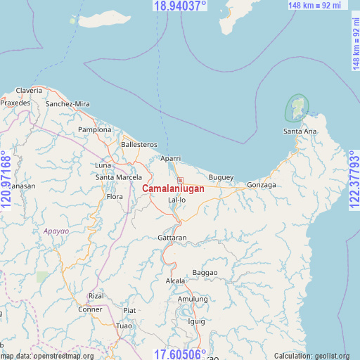
Camalaniugan GPS coordinates[2]
18° 16' 26.4" North, 121° 40' 29.28" East
| Map corner | latitude | longitude |
|---|---|---|
| Upper-left | 18.94037°, | 120.97168° |
| Center: | 18.274°, | 121.6748° |
| Lower-right: | 17.60506°, | 122.37793° |
| Map W x H: | 148.5×148.5 km | = 92.3×92.3mi |
| max Lat: | 20.78733° ⇑0.9% North |
| Camalaniugan: | 18.274° |
| min Lat: | ⇓99.1% South 4.65442° |
| min Long | Camalaniugan | max Long |
| 117.04868° | 121.6748° | 126.58417° |
| W 35.6%⇐ | ⇒64.4% E |
Elevation
Elevation of Camalaniugan is 5 m = 16 ft, and this is 82.9 m = 272 ft below average elevation for this country.
| Max E: |
2262 m = 7421 ft | 95.5% |
| Avg. | 87.9 m = 288 ft | |
| Camalaniugan | 5 m = 16 ft | |
Min E: |
-2 m = -7 ft | 4.5% |
See also: Philippines elevation on elevation.city.
Geographical zone
Camalaniugan is located in North Torrid zone (between Equator and Tropic of Cancer). Distance of this Northern Tropic circle is 574 km =356.7 mi to North.| Distance of | km | miles | from Camalaniugan |
|---|---|---|---|
| North Pole | 7975.2 | 4955.6 | to North |
| Arctic Circle | 5369.3 | 3336.3 | to North |
| Tropic Cancer | 574 | 356.7 | to North |
| Equator | 2031.9 | 1262.6 | to South |


Nearby cities:
15 places around Camalaniugan: (largest is in red/bold)
• Allacapan
13.6 km =8.5 mi,  246°
246°
• Aparri
9.9 km =6.2 mi,  338°
338°
• Bagumbayan
9 km =5.6 mi,  187°
187°
• Ballesteros
22.8 km =14.2 mi,  312°
312°
• Binalan
14.9 km =9.3 mi,  293°
293°
• Buguey
16.8 km =10.4 mi,  84°
84°
• Catayauan
12.8 km =8 mi, 190°
• Mabuttal East
20.4 km =12.7 mi,  303°
303°
• Magapit
15.2 km =9.4 mi,  182°
182°
• Magapit, Aguiguican
18.5 km =11.5 mi, 179°
• Maxingal
6.6 km =4.1 mi, 186°
• Paddaya
8.7 km =5.4 mi,  50°
50°
• Paddaya
10.7 km =6.6 mi,  66°
66°
• Pattao
15.1 km =9.4 mi,  101°
101°
• Santa Maria
14.8 km =9.2 mi, 184°
Sources, notices
• [Note1] Compared only with cities in Philippines existing in our database
• [Src1] Map data: © OpenStreetMap contributors (CC-BY-SA)
• [Src2] Other city data from geonames.org with taken over terms of usage.
• [Src3] Geographical zone / Annual Mean Temperature by Robert A. Rohde @ Wikipedia
