Mauhao geodata
Mauhao (Mimaropa) is a populated place; located in Philippines in Asia/Manila (GMT+8) time zone. With population of 2,310 people, there are 3654 cities with bigger population in this country. Compared to other cities in Philippines, 53.3% of cities are located further ↓South; 70.2% of cities are located further →East and 85.4% of cities have higher elevation than Mauhao. Note1
Administrative division(s):
- Level 1: Mimaropa
- Level 2: Province of Mindoro Oriental
- Level 3: Bulalacao (San Pedro)


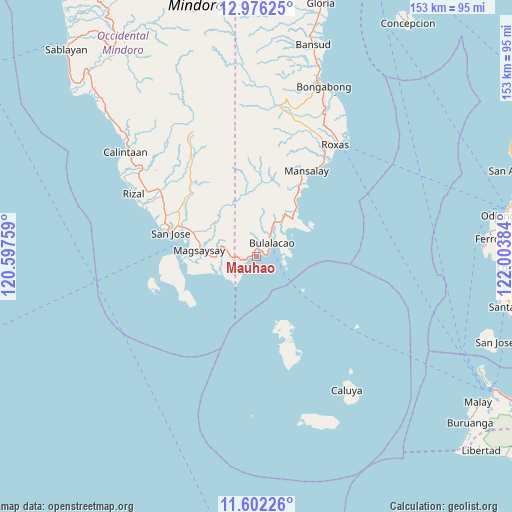
Mauhao GPS coordinates[2]
12° 17' 24.54" North, 121° 18' 2.556" East
| Map corner | latitude | longitude |
|---|---|---|
| Upper-left | 12.97625°, | 120.59759° |
| Center: | 12.29015°, | 121.30071° |
| Lower-right: | 11.60226°, | 122.00384° |
| Map W x H: | 152.8×152.8 km | = 94.9×94.9mi |
| max Lat: | 20.78733° ⇑46.7% North |
| Mauhao: | 12.29015° |
| min Lat: | ⇓53.3% South 4.65442° |
| min Long | Mauhao | max Long |
| 117.04868° | 121.30071° | 126.58417° |
| W 29.8%⇐ | ⇒70.2% E |
Elevation
Elevation of Mauhao is 8 m = 26 ft, and this is 79.9 m = 262 ft below average elevation for this country.
| Max E: |
2262 m = 7421 ft | 85.4% |
| Avg. | 87.9 m = 288 ft | |
| Mauhao | 8 m = 26 ft | |
Min E: |
-2 m = -7 ft | 14.6% |
See also: Philippines elevation on elevation.city.
Geographical zone
Mauhao is located in North Torrid zone (between Equator and Tropic of Cancer). Distance of this Northern Tropic circle is 1239.4 km =770.1 mi to North.| Distance of | km | miles | from Mauhao |
|---|---|---|---|
| North Pole | 8640.5 | 5369 | to North |
| Arctic Circle | 6034.6 | 3749.7 | to North |
| Tropic Cancer | 1239.4 | 770.1 | to North |
| Equator | 1366.5 | 849.1 | to South |


Nearby cities:
15 places around Mauhao: (largest is in red/bold)
• Alibug
10.4 km =6.5 mi,  229°
229°
• Babug
29.6 km =18.4 mi,  288°
288°
• Bagong Sikat
27.3 km =17 mi, 288°
• Bulalacao
6.1 km =3.8 mi,  49°
49°
• Caminauit
24.1 km =15 mi,  280°
280°
• La Curva
30.5 km =19 mi, 294°
• Magbay
26.5 km =16.5 mi,  300°
300°
• Magsaysay
17.1 km =10.6 mi, 286°
• Manaul
21.7 km =13.5 mi,  33°
33°
• Mangarine
23 km =14.3 mi, 287°
• Mansalay
29.7 km =18.5 mi, 30°
• Paclolo
16.8 km =10.4 mi, 304°
• San Jose
26.3 km =16.3 mi, 285°
• Santa Teresa
20.9 km =13 mi,  258°
258°
• Semirara
26.7 km =16.6 mi,  156°
156°
Sources, notices
• [Note1] Compared only with cities in Philippines existing in our database
• [Src1] Map data: © OpenStreetMap contributors (CC-BY-SA)
• [Src2] Other city data from geonames.org with taken over terms of usage.
• [Src3] Geographical zone / Annual Mean Temperature by Robert A. Rohde @ Wikipedia
