Alibug geodata
Alibug (Mimaropa) is a populated place; located in Philippines in Asia/Manila (GMT+8) time zone. With population of 2,576 people, there are 3152 cities with bigger population in this country. Compared to other cities in Philippines, 52.9% of cities are located further ↓South; 71.1% of cities are located further →East and 59.5% of cities have lower elevation than Alibug. Note1
Administrative division(s):
- Level 1: Mimaropa
- Level 2: Province of Mindoro Occidental
- Level 3: Magsaysay


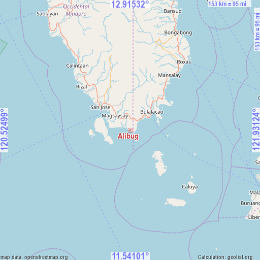
Alibug GPS coordinates[2]
12° 13' 44.616" North, 121° 13' 41.196" East
| Map corner | latitude | longitude |
|---|---|---|
| Upper-left | 12.91532°, | 120.52499° |
| Center: | 12.22906°, | 121.22811° |
| Lower-right: | 11.54101°, | 121.93124° |
| Map W x H: | 152.8×152.8 km | = 94.9×94.9mi |
| max Lat: | 20.78733° ⇑47.1% North |
| Alibug: | 12.22906° |
| min Lat: | ⇓52.9% South 4.65442° |
| min Long | Alibug | max Long |
| 117.04868° | 121.22811° | 126.58417° |
| W 28.9%⇐ | ⇒71.1% E |
Elevation
Elevation of Alibug is 33 m = 108 ft, and this is 54.9 m = 180 ft below average elevation for this country.
| Max E: |
2262 m = 7421 ft | 40.5% |
| Avg. | 87.9 m = 288 ft | |
| Alibug | 33 m = 108 ft | |
Min E: |
-2 m = -7 ft | 59.5% |
See also: Philippines elevation on elevation.city.
Geographical zone
Alibug is located in North Torrid zone (between Equator and Tropic of Cancer). Distance of this Northern Tropic circle is 1246.2 km =774.4 mi to North.| Distance of | km | miles | from Alibug |
|---|---|---|---|
| North Pole | 8647.3 | 5373.2 | to North |
| Arctic Circle | 6041.4 | 3754 | to North |
| Tropic Cancer | 1246.2 | 774.4 | to North |
| Equator | 1359.7 | 844.9 | to South |


Nearby cities:
15 places around Alibug: (largest is in red/bold)
• Babug
25.8 km =16 mi,  308°
308°
• Bagong Sikat
23.7 km =14.7 mi, 310°
• Bulalacao
16.5 km =10.3 mi,  49°
49°
• Caminauit
19.5 km =12.1 mi, 305°
• La Curva
27.8 km =17.3 mi, 314°
• Magbay
25.1 km =15.6 mi,  323°
323°
• Magsaysay
14.4 km =8.9 mi, 323°
• Manaul
31.8 km =19.8 mi,  38°
38°
• Mangarine
19.6 km =12.2 mi, 313°
• Mauhao
10.4 km =6.5 mi, 49°
• Paclolo
17.5 km =10.9 mi,  340°
340°
• San Jose
22.2 km =13.8 mi, 308°
• Santa Teresa
12.8 km =8 mi,  281°
281°
• Semirara
25.6 km =15.9 mi,  133°
133°
• Tinogboc
31.8 km =19.8 mi,  140°
140°
Sources, notices
• [Note1] Compared only with cities in Philippines existing in our database
• [Src1] Map data: © OpenStreetMap contributors (CC-BY-SA)
• [Src2] Other city data from geonames.org with taken over terms of usage.
• [Src3] Geographical zone / Annual Mean Temperature by Robert A. Rohde @ Wikipedia
