Tagnanan geodata
Tagnanan (Davao) is a populated place; located in Philippines in Asia/Manila (GMT+8) time zone. With population of 4,171 people, there are 1635 cities with bigger population in this country. Compared to other cities in Philippines, 88.7% of cities are located further ↑North; 96.8% of cities are located further ←West and 70.2% of cities have higher elevation than Tagnanan. Note1


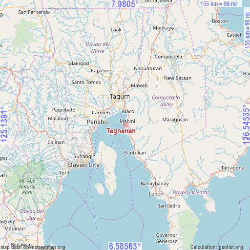
Tagnanan GPS coordinates[2]
7° 17' 0.996" North, 125° 50' 31.992" East
| Map corner | latitude | longitude |
|---|---|---|
| Upper-left | 7.9805°, | 125.1391° |
| Center: | 7.28361°, | 125.84222° |
| Lower-right: | 6.58563°, | 126.54535° |
| Map W x H: | 155.1×155.1 km | = 96.4×96.4mi |
| max Lat: | 20.78733° ⇑88.7% North |
| Tagnanan: | 7.28361° |
| min Lat: | ⇓11.3% South 4.65442° |
| min Long | Tagnanan | max Long |
| 117.04868° | 125.84222° | 126.58417° |
| W 96.8%⇐ | ⇒3.2% E |
Elevation
Elevation of Tagnanan is 12 m = 39 ft, and this is 75.9 m = 249 ft below average elevation for this country.
| Max E: |
2262 m = 7421 ft | 70.2% |
| Avg. | 87.9 m = 288 ft | |
| Tagnanan | 12 m = 39 ft | |
Min E: |
-2 m = -7 ft | 29.8% |
See also: Philippines elevation on elevation.city.
Geographical zone
Tagnanan is located in North Torrid zone (between Equator and Tropic of Cancer). Distance of Equator is 809.9 km =503.2 mi to South.| Distance of | km | miles | from Tagnanan |
|---|---|---|---|
| North Pole | 9197.2 | 5714.9 | to North |
| Arctic Circle | 6591.3 | 4095.6 | to North |
| Tropic Cancer | 1796.1 | 1116 | to North |
| Equator | 809.9 | 503.2 | to South |


Nearby cities:
15 places around Tagnanan: (largest is in red/bold)
• Bincoñgan
13.7 km =8.5 mi,  312°
312°
• Bungabon
7.6 km =4.7 mi,  153°
153°
• Corocotan
15 km =9.3 mi,  329°
329°
• Cuambog
2.9 km =1.8 mi,  13°
13°
• Hiju, Maco
11.4 km =7.1 mi,  352°
352°
• La Paz
12.5 km =7.8 mi,  286°
286°
• Libuganon
10.1 km =6.3 mi,  315°
315°
• Mabini
3.3 km =2.1 mi,  20°
20°
• Maco
8.8 km =5.5 mi, 9°
• Magnaga
13.9 km =8.6 mi,  156°
156°
• Pandasan
1.2 km =0.7 mi,  89°
89°
• Pantukan
14.8 km =9.2 mi, 154°
• Santo Niño
15.9 km =9.9 mi, 288°
• Tagdanua
10 km =6.2 mi, 152°
• Tibagon
6.1 km =3.8 mi, 158°
Sources, notices
• [Note1] Compared only with cities in Philippines existing in our database
• [Src1] Map data: © OpenStreetMap contributors (CC-BY-SA)
• [Src2] Other city data from geonames.org with taken over terms of usage.
• [Src3] Geographical zone / Annual Mean Temperature by Robert A. Rohde @ Wikipedia
