Bungabon geodata
Bungabon (Davao) is a populated place; located in Philippines in Asia/Manila (GMT+8) time zone. With population of 3,888 people, there are 1794 cities with bigger population in this country. Compared to other cities in Philippines, 89.2% of cities are located further ↑North; 97% of cities are located further ←West and 53.1% of cities have higher elevation than Bungabon. Note1


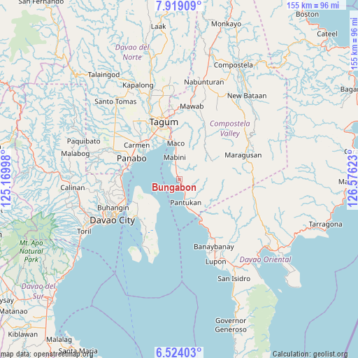
Bungabon GPS coordinates[2]
7° 13' 19.56" North, 125° 52' 23.16" East
| Map corner | latitude | longitude |
|---|---|---|
| Upper-left | 7.91909°, | 125.16998° |
| Center: | 7.2221°, | 125.8731° |
| Lower-right: | 6.52403°, | 126.57623° |
| Map W x H: | 155.1×155.1 km | = 96.4×96.4mi |
| max Lat: | 20.78733° ⇑89.2% North |
| Bungabon: | 7.2221° |
| min Lat: | ⇓10.8% South 4.65442° |
| min Long | Bungabon | max Long |
| 117.04868° | 125.8731° | 126.58417° |
| W 97%⇐ | ⇒3% E |
Elevation
Elevation of Bungabon is 21 m = 69 ft, and this is 66.9 m = 219 ft below average elevation for this country.
| Max E: |
2262 m = 7421 ft | 53.1% |
| Avg. | 87.9 m = 288 ft | |
| Bungabon | 21 m = 69 ft | |
Min E: |
-2 m = -7 ft | 46.9% |
See also: Philippines elevation on elevation.city.
Geographical zone
Bungabon is located in North Torrid zone (between Equator and Tropic of Cancer). Distance of Equator is 803 km =499 mi to South.| Distance of | km | miles | from Bungabon |
|---|---|---|---|
| North Pole | 9204 | 5719.1 | to North |
| Arctic Circle | 6598.2 | 4099.9 | to North |
| Tropic Cancer | 1802.9 | 1120.3 | to North |
| Equator | 803 | 499 | to South |


Nearby cities:
15 places around Bungabon: (largest is in red/bold)
• Aumbay
16.5 km =10.3 mi,  216°
216°
• Cuambog
10 km =6.2 mi,  343°
343°
• La Paz
18.6 km =11.6 mi,  304°
304°
• Libuganon
17.6 km =10.9 mi,  323°
323°
• Mabini
10.2 km =6.3 mi,  347°
347°
• Maco
15.7 km =9.8 mi, 352°
• Magnaga
6.3 km =3.9 mi,  159°
159°
• Matiao
17 km =10.6 mi, 155°
• Pandasan
7.2 km =4.5 mi, 342°
• Pantukan
7.1 km =4.4 mi, 156°
• San Antonio
18.6 km =11.6 mi,  232°
232°
• Tagdanua
2.3 km =1.4 mi,  148°
148°
• Tagnanan
7.6 km =4.7 mi,  333°
333°
• Tibagon
1.6 km =1 mi, 316°
• Tombongon
17.9 km =11.1 mi, 152°
Sources, notices
• [Note1] Compared only with cities in Philippines existing in our database
• [Src1] Map data: © OpenStreetMap contributors (CC-BY-SA)
• [Src2] Other city data from geonames.org with taken over terms of usage.
• [Src3] Geographical zone / Annual Mean Temperature by Robert A. Rohde @ Wikipedia
