Ilangay geodata
Ilangay (Davao) is a populated place; located in Philippines in Asia/Manila (GMT+8) time zone. With population of 3,460 people, there are 2096 cities with bigger population in this country. Compared to other cities in Philippines, 92.5% of cities are located further ↑North; 98.1% of cities are located further ←West and 59.5% of cities have lower elevation than Ilangay. Note1


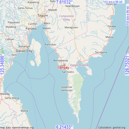
Ilangay GPS coordinates[2]
6° 54' 46.224" North, 126° 3' 0.288" East
| Map corner | latitude | longitude |
|---|---|---|
| Upper-left | 7.61032°, | 125.34696° |
| Center: | 6.91284°, | 126.05008° |
| Lower-right: | 6.21433°, | 126.75321° |
| Map W x H: | 155.2×155.2 km | = 96.4×96.4mi |
| max Lat: | 20.78733° ⇑92.5% North |
| Ilangay: | 6.91284° |
| min Lat: | ⇓7.5% South 4.65442° |
| min Long | Ilangay | max Long |
| 117.04868° | 126.05008° | 126.58417° |
| W 98.1%⇐ | ⇒1.9% E |
Elevation
Elevation of Ilangay is 33 m = 108 ft, and this is 54.9 m = 180 ft below average elevation for this country.
| Max E: |
2262 m = 7421 ft | 40.5% |
| Avg. | 87.9 m = 288 ft | |
| Ilangay | 33 m = 108 ft | |
Min E: |
-2 m = -7 ft | 59.5% |
See also: Philippines elevation on elevation.city.
Geographical zone
Ilangay is located in North Torrid zone (between Equator and Tropic of Cancer). Distance of Equator is 768.6 km =477.6 mi to South.| Distance of | km | miles | from Ilangay |
|---|---|---|---|
| North Pole | 9238.4 | 5740.5 | to North |
| Arctic Circle | 6632.5 | 4121.2 | to North |
| Tropic Cancer | 1837.3 | 1141.6 | to North |
| Equator | 768.6 | 477.6 | to South |


Nearby cities:
15 places around Ilangay: (largest is in red/bold)
• Banaybanay
6.6 km =4.1 mi,  326°
326°
• Baon
13.7 km =8.5 mi,  162°
162°
• Batobato
10.5 km =6.5 mi, 158°
• Bitaogan
16.3 km =10.1 mi,  169°
169°
• Davan
11.4 km =7.1 mi,  88°
88°
• La Union
23.6 km =14.7 mi, 169°
• Limot
28.4 km =17.6 mi,  59°
59°
• Linao
13.3 km =8.3 mi, 331°
• Lupon
4.8 km =3 mi,  249°
249°
• Manikling
3.9 km =2.4 mi, 162°
• Mati
19 km =11.8 mi,  75°
75°
• Matiao
22.7 km =14.1 mi, 326°
• Panikian
11.3 km =7 mi,  345°
345°
• Talisay
22.2 km =13.8 mi, 165°
• Tombongon
21.6 km =13.4 mi, 328°
Sources, notices
• [Note1] Compared only with cities in Philippines existing in our database
• [Src1] Map data: © OpenStreetMap contributors (CC-BY-SA)
• [Src2] Other city data from geonames.org with taken over terms of usage.
• [Src3] Geographical zone / Annual Mean Temperature by Robert A. Rohde @ Wikipedia
