Panikian geodata
Panikian (Davao) is a populated place; located in Philippines in Asia/Manila (GMT+8) time zone. With population of 2,878 people, there are 2666 cities with bigger population in this country. Compared to other cities in Philippines, 91.6% of cities are located further ↑North; 97.9% of cities are located further ←West and 57.4% of cities have lower elevation than Panikian. Note1


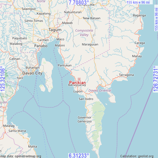
Panikian GPS coordinates[2]
7° 0' 38.52" North, 126° 1' 27.048" East
| Map corner | latitude | longitude |
|---|---|---|
| Upper-left | 7.70803°, | 125.32106° |
| Center: | 7.0107°, | 126.02418° |
| Lower-right: | 6.31233°, | 126.72731° |
| Map W x H: | 155.2×155.2 km | = 96.4×96.4mi |
| max Lat: | 20.78733° ⇑91.6% North |
| Panikian: | 7.0107° |
| min Lat: | ⇓8.4% South 4.65442° |
| min Long | Panikian | max Long |
| 117.04868° | 126.02418° | 126.58417° |
| W 97.9%⇐ | ⇒2.1% E |
Elevation
Elevation of Panikian is 30 m = 98 ft, and this is 57.9 m = 190 ft below average elevation for this country.
| Max E: |
2262 m = 7421 ft | 42.6% |
| Avg. | 87.9 m = 288 ft | |
| Panikian | 30 m = 98 ft | |
Min E: |
-2 m = -7 ft | 57.4% |
See also: Philippines elevation on elevation.city.
Geographical zone
Panikian is located in North Torrid zone (between Equator and Tropic of Cancer). Distance of Equator is 779.5 km =484.4 mi to South.| Distance of | km | miles | from Panikian |
|---|---|---|---|
| North Pole | 9227.5 | 5733.7 | to North |
| Arctic Circle | 6621.7 | 4114.5 | to North |
| Tropic Cancer | 1826.4 | 1134.9 | to North |
| Equator | 779.5 | 484.4 | to South |


Nearby cities:
15 places around Panikian: (largest is in red/bold)
• Banaybanay
5.4 km =3.4 mi,  188°
188°
• Baon
24.9 km =15.5 mi,  163°
163°
• Batobato
21.7 km =13.5 mi, 162°
• Davan
17.8 km =11.1 mi,  126°
126°
• Ilangay
11.3 km =7 mi,  165°
165°
• Limot
27.6 km =17.1 mi,  83°
83°
• Linao
3.6 km =2.2 mi,  281°
281°
• Lupon
12.6 km =7.8 mi, 187°
• Magnaga
22.8 km =14.2 mi,  320°
320°
• Manikling
15.2 km =9.4 mi, 164°
• Mati
22.1 km =13.7 mi,  106°
106°
• Matiao
12.6 km =7.8 mi,  309°
309°
• Pantukan
21.9 km =13.6 mi, 320°
• Tagdanua
26.5 km =16.5 mi, 324°
• Tombongon
11.3 km =7 mi, 312°
Sources, notices
• [Note1] Compared only with cities in Philippines existing in our database
• [Src1] Map data: © OpenStreetMap contributors (CC-BY-SA)
• [Src2] Other city data from geonames.org with taken over terms of usage.
• [Src3] Geographical zone / Annual Mean Temperature by Robert A. Rohde @ Wikipedia
