Masbate geodata
Masbate (Bicol) is a seat of a third-order administrative division; located in Philippines in Asia/Manila (GMT+8) time zone. With population of 47,490 people, there are 184 cities with bigger population in this country. Compared to other cities in Philippines, 53.9% of cities are located further ↓South; 64.3% of cities are located further ←West and 70.2% of cities have higher elevation than Masbate. Note1


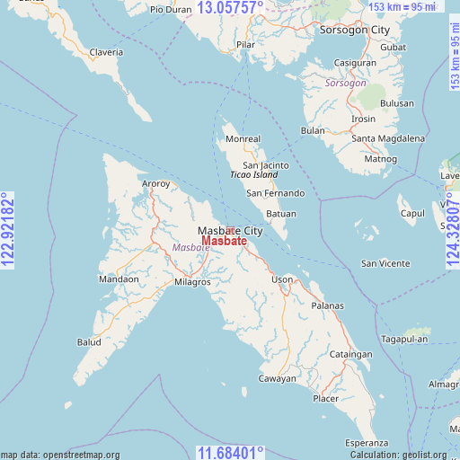
Masbate GPS coordinates[2]
12° 22' 18.084" North, 123° 37' 29.784" East
| Map corner | latitude | longitude |
|---|---|---|
| Upper-left | 13.05757°, | 122.92182° |
| Center: | 12.37169°, | 123.62494° |
| Lower-right: | 11.68401°, | 124.32807° |
| Map W x H: | 152.7×152.7 km | = 94.9×94.9mi |
| max Lat: | 20.78733° ⇑46.1% North |
| Masbate: | 12.37169° |
| min Lat: | ⇓53.9% South 4.65442° |
| min Long | Masbate | max Long |
| 117.04868° | 123.62494° | 126.58417° |
| W 64.3%⇐ | ⇒35.7% E |
Elevation
Elevation of Masbate is 12 m = 39 ft, and this is 75.9 m = 249 ft below average elevation for this country.
| Max E: |
2262 m = 7421 ft | 70.2% |
| Avg. | 87.9 m = 288 ft | |
| Masbate | 12 m = 39 ft | |
Min E: |
-2 m = -7 ft | 29.8% |
See also: Masbate elevation on elevation.city.
Geographical zone
Masbate is located in North Torrid zone (between Equator and Tropic of Cancer). Distance of this Northern Tropic circle is 1230.3 km =764.5 mi to North.| Distance of | km | miles | from Masbate |
|---|---|---|---|
| North Pole | 8631.5 | 5363.4 | to North |
| Arctic Circle | 6025.6 | 3744.1 | to North |
| Tropic Cancer | 1230.3 | 764.5 | to North |
| Equator | 1375.6 | 854.8 | to South |


Nearby cities:
15 places around Masbate: (largest is in red/bold)
• Armenia
18.4 km =11.4 mi,  135°
135°
• Bacolod
20.3 km =12.6 mi,  218°
218°
• Baleno
17.8 km =11.1 mi,  309°
309°
• Batuan
15.2 km =9.4 mi,  79°
79°
• Bulo
7.6 km =4.7 mi,  304°
304°
• Calachuchi
19.9 km =12.4 mi,  210°
210°
• Hamoraon
18.1 km =11.2 mi, 206°
• Malinta
10.7 km =6.6 mi, 222°
• Marintoc
14.3 km =8.9 mi,  132°
132°
• Mayngaran
3.7 km =2.3 mi,  227°
227°
• Milagros
21.2 km =13.2 mi, 216°
• Mobo
5.3 km =3.3 mi, 138°
• San Fernando
19.4 km =12.1 mi,  50°
50°
• Umabay
9.1 km =5.7 mi, 139°
• Usab
6.7 km =4.2 mi, 225°
Sources, notices
• [Note1] Compared only with cities in Philippines existing in our database
• [Src1] Map data: © OpenStreetMap contributors (CC-BY-SA)
• [Src2] Other city data from geonames.org with taken over terms of usage.
• [Src3] Geographical zone / Annual Mean Temperature by Robert A. Rohde @ Wikipedia
