Batuan geodata
Batuan (Bicol) is a seat of a third-order administrative division; located in Philippines in Asia/Manila (GMT+8) time zone. With population of 2,516 people, there are 3260 cities with bigger population in this country. Compared to other cities in Philippines, 54.1% of cities are located further ↓South; 67.2% of cities are located further ←West and 88.4% of cities have lower elevation than Batuan. Note1


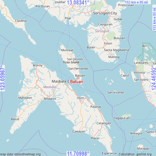
Batuan GPS coordinates[2]
12° 23' 51.36" North, 123° 45' 46.044" East
| Map corner | latitude | longitude |
|---|---|---|
| Upper-left | 13.08341°, | 123.05967° |
| Center: | 12.3976°, | 123.76279° |
| Lower-right: | 11.70998°, | 124.46592° |
| Map W x H: | 152.7×152.7 km | = 94.9×94.9mi |
| max Lat: | 20.78733° ⇑45.9% North |
| Batuan: | 12.3976° |
| min Lat: | ⇓54.1% South 4.65442° |
| min Long | Batuan | max Long |
| 117.04868° | 123.76279° | 126.58417° |
| W 67.2%⇐ | ⇒32.8% E |
Elevation
Elevation of Batuan is 190 m = 623 ft, and this is 102.1 m = 335 ft above average elevation for this country.
| Max E: |
2262 m = 7421 ft | 11.6% |
| Batuan | 190 m 623 ft | |
| Avg. | 87.9 m = 288 ft | |
Min E: |
-2 m = -7 ft | 88.4% |
See also: Philippines elevation on elevation.city.
Geographical zone
Batuan is located in North Torrid zone (between Equator and Tropic of Cancer). Distance of this Northern Tropic circle is 1227.4 km =762.7 mi to North.| Distance of | km | miles | from Batuan |
|---|---|---|---|
| North Pole | 8628.6 | 5361.6 | to North |
| Arctic Circle | 6022.7 | 3742.3 | to North |
| Tropic Cancer | 1227.4 | 762.7 | to North |
| Equator | 1378.5 | 856.6 | to South |


Nearby cities:
15 places around Batuan: (largest is in red/bold)
• Armenia
16.2 km =10.1 mi,  187°
187°
• Bagahanlad
22.7 km =14.1 mi,  333°
333°
• Bulo
21.3 km =13.2 mi,  273°
273°
• Dapdap
20.3 km =12.6 mi,  178°
178°
• Luna
17.2 km =10.7 mi,  349°
349°
• Marintoc
13.2 km =8.2 mi,  199°
199°
• Masbate
15.2 km =9.4 mi,  259°
259°
• Mayngaran
18.5 km =11.5 mi,  253°
253°
• Miaga
18.7 km =11.6 mi,  161°
161°
• Mobo
13.3 km =8.3 mi,  239°
239°
• San Fernando
9.5 km =5.9 mi,  359°
359°
• San Jacinto
19.2 km =11.9 mi, 350°
• Umabay
13.3 km =8.3 mi,  222°
222°
• Usab
21.1 km =13.1 mi, 249°
• Uson
19.3 km =12 mi,  173°
173°
Sources, notices
• [Note1] Compared only with cities in Philippines existing in our database
• [Src1] Map data: © OpenStreetMap contributors (CC-BY-SA)
• [Src2] Other city data from geonames.org with taken over terms of usage.
• [Src3] Geographical zone / Annual Mean Temperature by Robert A. Rohde @ Wikipedia
