San Fernando geodata
San Fernando (Bicol) is a seat of a third-order administrative division; located in Philippines in Asia/Manila (GMT+8) time zone. With population of 6,211 people, there are 1003 cities with bigger population in this country. Compared to other cities in Philippines, 54.7% of cities are located further ↓South; 67.2% of cities are located further ←West and 89.7% of cities have higher elevation than San Fernando. Note1


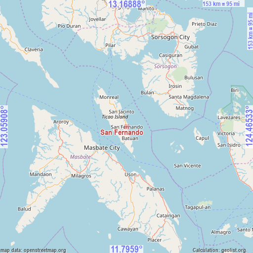
San Fernando GPS coordinates[2]
12° 28' 59.88" North, 123° 45' 43.92" East
| Map corner | latitude | longitude |
|---|---|---|
| Upper-left | 13.16888°, | 123.05908° |
| Center: | 12.4833°, | 123.7622° |
| Lower-right: | 11.7959°, | 124.46533° |
| Map W x H: | 152.7×152.7 km | = 94.9×94.9mi |
| max Lat: | 20.78733° ⇑45.3% North |
| San Fernando: | 12.4833° |
| min Lat: | ⇓54.7% South 4.65442° |
| min Long | San Fernando | max Long |
| 117.04868° | 123.7622° | 126.58417° |
| W 67.2%⇐ | ⇒32.8% E |
Elevation
Elevation of San Fernando is 7 m = 23 ft, and this is 80.9 m = 265 ft below average elevation for this country.
| Max E: |
2262 m = 7421 ft | 89.7% |
| Avg. | 87.9 m = 288 ft | |
| San Fernando | 7 m = 23 ft | |
Min E: |
-2 m = -7 ft | 10.3% |
See also: Philippines elevation on elevation.city.
Geographical zone
San Fernando is located in North Torrid zone (between Equator and Tropic of Cancer). Distance of this Northern Tropic circle is 1217.9 km =756.8 mi to North.| Distance of | km | miles | from San Fernando |
|---|---|---|---|
| North Pole | 8619 | 5355.6 | to North |
| Arctic Circle | 6013.2 | 3736.4 | to North |
| Tropic Cancer | 1217.9 | 756.8 | to North |
| Equator | 1388 | 862.5 | to South |


Nearby cities:
15 places around San Fernando: (largest is in red/bold)
• Bagahanlad
14.8 km =9.2 mi,  316°
316°
• Batuan
9.5 km =5.9 mi,  179°
179°
• Bulan
24.2 km =15 mi,  30°
30°
• Bulo
22.7 km =14.1 mi,  249°
249°
• Butag
24.7 km =15.3 mi,  48°
48°
• Luna
8 km =5 mi,  337°
337°
• Marintoc
22.4 km =13.9 mi,  191°
191°
• Masbate
19.4 km =12.1 mi,  230°
230°
• Mayngaran
23.1 km =14.4 mi, 229°
• Mobo
19.9 km =12.4 mi,  214°
214°
• Monreal
20.8 km =12.9 mi,  329°
329°
• Quezon
24.2 km =15 mi,  57°
57°
• San Jacinto
9.9 km =6.2 mi, 341°
• Umabay
21.3 km =13.2 mi,  204°
204°
• Utabi
23.8 km =14.8 mi,  42°
42°
Sources, notices
• [Note1] Compared only with cities in Philippines existing in our database
• [Src1] Map data: © OpenStreetMap contributors (CC-BY-SA)
• [Src2] Other city data from geonames.org with taken over terms of usage.
• [Src3] Geographical zone / Annual Mean Temperature by Robert A. Rohde @ Wikipedia
