Bulo geodata
Bulo (Bicol) is a populated place; located in Philippines in Asia/Manila (GMT+8) time zone. With population of 2,705 people, there are 2936 cities with bigger population in this country. Compared to other cities in Philippines, 54.2% of cities are located further ↓South; 63.5% of cities are located further ←West and 89.7% of cities have higher elevation than Bulo. Note1


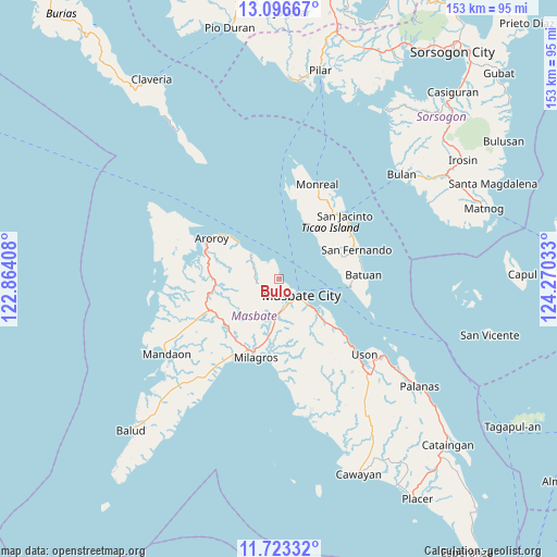
Bulo GPS coordinates[2]
12° 24' 39.24" North, 123° 34' 1.92" East
| Map corner | latitude | longitude |
|---|---|---|
| Upper-left | 13.09667°, | 122.86408° |
| Center: | 12.4109°, | 123.5672° |
| Lower-right: | 11.72332°, | 124.27033° |
| Map W x H: | 152.7×152.7 km | = 94.9×94.9mi |
| max Lat: | 20.78733° ⇑45.8% North |
| Bulo: | 12.4109° |
| min Lat: | ⇓54.2% South 4.65442° |
| min Long | Bulo | max Long |
| 117.04868° | 123.5672° | 126.58417° |
| W 63.5%⇐ | ⇒36.5% E |
Elevation
Elevation of Bulo is 7 m = 23 ft, and this is 80.9 m = 265 ft below average elevation for this country.
| Max E: |
2262 m = 7421 ft | 89.7% |
| Avg. | 87.9 m = 288 ft | |
| Bulo | 7 m = 23 ft | |
Min E: |
-2 m = -7 ft | 10.3% |
See also: Philippines elevation on elevation.city.
Geographical zone
Bulo is located in North Torrid zone (between Equator and Tropic of Cancer). Distance of this Northern Tropic circle is 1226 km =761.8 mi to North.| Distance of | km | miles | from Bulo |
|---|---|---|---|
| North Pole | 8627.1 | 5360.6 | to North |
| Arctic Circle | 6021.2 | 3741.4 | to North |
| Tropic Cancer | 1226 | 761.8 | to North |
| Equator | 1380 | 857.5 | to South |


Nearby cities:
15 places around Bulo: (largest is in red/bold)
• Aroroy
21.5 km =13.4 mi,  301°
301°
• Bacolod
21.3 km =13.2 mi,  197°
197°
• Bagahanlad
21.8 km =13.5 mi,  30°
30°
• Baleno
10.3 km =6.4 mi,  313°
313°
• Batuan
21.3 km =13.2 mi,  93°
93°
• Calachuchi
21.8 km =13.5 mi,  190°
190°
• Hamoraon
20.7 km =12.9 mi,  184°
184°
• Malinta
12.2 km =7.6 mi, 184°
• Masbate
7.6 km =4.7 mi,  124°
124°
• Mayngaran
7.7 km =4.8 mi,  152°
152°
• Mobo
12.8 km =8 mi,  130°
130°
• Paniqui
20.6 km =12.8 mi,  283°
283°
• Puro
21.6 km =13.4 mi,  292°
292°
• Umabay
16.6 km =10.3 mi, 132°
• Usab
9.1 km =5.7 mi,  170°
170°
Sources, notices
• [Note1] Compared only with cities in Philippines existing in our database
• [Src1] Map data: © OpenStreetMap contributors (CC-BY-SA)
• [Src2] Other city data from geonames.org with taken over terms of usage.
• [Src3] Geographical zone / Annual Mean Temperature by Robert A. Rohde @ Wikipedia
