Cabangahan geodata
Cabangahan (Central Visayas) is a populated place; located in Philippines in Asia/Manila (GMT+8) time zone. With population of 3,861 people, there are 1803 cities with bigger population in this country. Compared to other cities in Philippines, 75.4% of cities are located further ↑North; 52.4% of cities are located further ←West and 50.3% of cities have higher elevation than Cabangahan. Note1
Administrative division(s):
- Level 1: Central Visayas
- Level 2: Province of Negros Oriental
- Level 3: Siaton


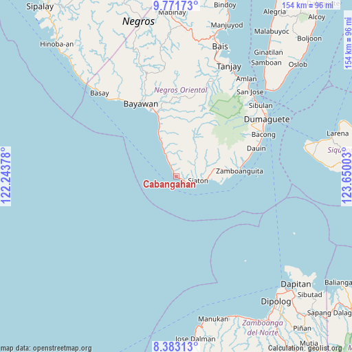
Cabangahan GPS coordinates[2]
9° 4' 41.16" North, 122° 56' 48.84" East
| Map corner | latitude | longitude |
|---|---|---|
| Upper-left | 9.77173°, | 122.24378° |
| Center: | 9.0781°, | 122.9469° |
| Lower-right: | 8.38313°, | 123.65003° |
| Map W x H: | 154.4×154.4 km | = 95.9×95.9mi |
| max Lat: | 20.78733° ⇑75.4% North |
| Cabangahan: | 9.0781° |
| min Lat: | ⇓24.6% South 4.65442° |
| min Long | Cabangahan | max Long |
| 117.04868° | 122.9469° | 126.58417° |
| W 52.4%⇐ | ⇒47.6% E |
Elevation
Elevation of Cabangahan is 23 m = 75 ft, and this is 64.9 m = 213 ft below average elevation for this country.
| Max E: |
2262 m = 7421 ft | 50.3% |
| Avg. | 87.9 m = 288 ft | |
| Cabangahan | 23 m = 75 ft | |
Min E: |
-2 m = -7 ft | 49.7% |
See also: Philippines elevation on elevation.city.
Geographical zone
Cabangahan is located in North Torrid zone (between Equator and Tropic of Cancer). Distance of Equator is 1009.4 km =627.2 mi to South.| Distance of | km | miles | from Cabangahan |
|---|---|---|---|
| North Pole | 8997.7 | 5590.9 | to North |
| Arctic Circle | 6391.8 | 3971.7 | to North |
| Tropic Cancer | 1596.5 | 992 | to North |
| Equator | 1009.4 | 627.2 | to South |


Nearby cities:
15 places around Cabangahan: (largest is in red/bold)
• Alangilan
23.6 km =14.7 mi,  341°
341°
• Apoya
16.5 km =10.3 mi, 343°
• Bonawon
6.9 km =4.3 mi,  334°
334°
• Canauay
11.7 km =7.3 mi,  97°
97°
• Casala-an
12.1 km =7.5 mi,  69°
69°
• Caticugan
6.3 km =3.9 mi, 67°
• Maloh
4.9 km =3 mi,  120°
120°
• Manalongon
17.2 km =10.7 mi, 337°
• Mantiquil
15 km =9.3 mi,  48°
48°
• Mayabon
25 km =15.5 mi,  85°
85°
• Nagbalaye
20.6 km =12.8 mi, 337°
• Sandolot
8.5 km =5.3 mi, 69°
• Santa Catalina
29.9 km =18.6 mi, 342°
• Siaton
9.7 km =6 mi, 98°
• Zamboanguita
27.9 km =17.3 mi,  84°
84°
Sources, notices
• [Note1] Compared only with cities in Philippines existing in our database
• [Src1] Map data: © OpenStreetMap contributors (CC-BY-SA)
• [Src2] Other city data from geonames.org with taken over terms of usage.
• [Src3] Geographical zone / Annual Mean Temperature by Robert A. Rohde @ Wikipedia
