Malabanban Norte geodata
Malabanban Norte (Calabarzon) is a populated place; located in Philippines in Asia/Manila (GMT+8) time zone. With population of 19,471 people, there are 375 cities with bigger population in this country. Compared to other cities in Philippines, 68.3% of cities are located further ↓South; 68% of cities are located further →East and 81.4% of cities have lower elevation than Malabanban Norte. Note1


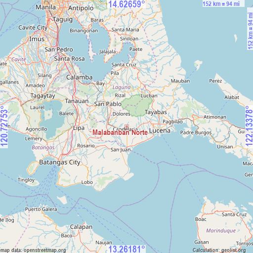
Malabanban Norte GPS coordinates[2]
13° 56' 42.756" North, 121° 25' 50.34" East
| Map corner | latitude | longitude |
|---|---|---|
| Upper-left | 14.62659°, | 120.72753° |
| Center: | 13.94521°, | 121.43065° |
| Lower-right: | 13.26181°, | 122.13378° |
| Map W x H: | 151.7×151.8 km | = 94.3×94.3mi |
| max Lat: | 20.78733° ⇑31.7% North |
| Malabanban Norte: | 13.94521° |
| min Lat: | ⇓68.3% South 4.65442° |
| min Long | Malabanban Nort | max Long |
| 117.04868° | 121.43065° | 126.58417° |
| W 32%⇐ | ⇒68% E |
Elevation
Elevation of Malabanban Norte is 102 m = 335 ft, and this is 14.1 m = 46 ft above average elevation for this country.
| Max E: |
2262 m = 7421 ft | 18.6% |
| Malabanban Norte | 102 m 335 ft | |
| Avg. | 87.9 m = 288 ft | |
Min E: |
-2 m = -7 ft | 81.4% |
See also: Philippines elevation on elevation.city.
Geographical zone
Malabanban Norte is located in North Torrid zone (between Equator and Tropic of Cancer). Distance of this Northern Tropic circle is 1055.4 km =655.8 mi to North.| Distance of | km | miles | from Malabanban Norte |
|---|---|---|---|
| North Pole | 8456.5 | 5254.6 | to North |
| Arctic Circle | 5850.6 | 3635.4 | to North |
| Tropic Cancer | 1055.4 | 655.8 | to North |
| Equator | 1550.6 | 963.5 | to South |


Nearby cities:
15 places around Malabanban Norte: (largest is in red/bold)
• Bukal Sur
4.9 km =3 mi,  260°
260°
• Bungoy
9.1 km =5.7 mi,  309°
309°
• Cabatang
7.3 km =4.5 mi,  289°
289°
• Cabay
9.9 km =6.2 mi,  213°
213°
• Candelaria
1.8 km =1.1 mi, 206°
• Concepcion Ibaba
4.1 km =2.5 mi,  126°
126°
• Dagatan
8.6 km =5.3 mi,  317°
317°
• Dolores
8.9 km =5.5 mi,  345°
345°
• Janagdong
10.1 km =6.3 mi,  117°
117°
• Lusacan
9.3 km =5.8 mi,  276°
276°
• Masalukot Uno
1.7 km =1.1 mi, 311°
• Montecillo
7.8 km =4.8 mi,  141°
141°
• Paiisa
8.5 km =5.3 mi, 255°
• Santa Catalina Sur
7.9 km =4.9 mi,  179°
179°
• Santa Lucia
10 km =6.2 mi,  0°
0°
Sources, notices
• [Note1] Compared only with cities in Philippines existing in our database
• [Src1] Map data: © OpenStreetMap contributors (CC-BY-SA)
• [Src2] Other city data from geonames.org with taken over terms of usage.
• [Src3] Geographical zone / Annual Mean Temperature by Robert A. Rohde @ Wikipedia
