Candelaria geodata
Candelaria (Calabarzon) is a seat of a third-order administrative division; located in Philippines in Asia/Manila (GMT+8) time zone. With population of 60,881 people, there are 154 cities with bigger population in this country. Compared to other cities in Philippines, 68% of cities are located further ↓South; 68.2% of cities are located further →East and 76% of cities have lower elevation than Candelaria. Note1


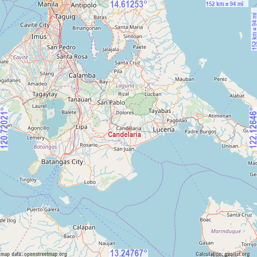
Candelaria GPS coordinates[2]
13° 55' 51.996" North, 121° 25' 23.988" East
| Map corner | latitude | longitude |
|---|---|---|
| Upper-left | 14.61253°, | 120.72021° |
| Center: | 13.93111°, | 121.42333° |
| Lower-right: | 13.24767°, | 122.12646° |
| Map W x H: | 151.8×151.8 km | = 94.3×94.3mi |
| max Lat: | 20.78733° ⇑32% North |
| Candelaria: | 13.93111° |
| min Lat: | ⇓68% South 4.65442° |
| min Long | Candelaria | max Long |
| 117.04868° | 121.42333° | 126.58417° |
| W 31.8%⇐ | ⇒68.2% E |
Elevation
Elevation of Candelaria is 72 m = 236 ft, and this is 15.9 m = 52 ft below average elevation for this country.
| Max E: |
2262 m = 7421 ft | 24% |
| Avg. | 87.9 m = 288 ft | |
| Candelaria | 72 m = 236 ft | |
Min E: |
-2 m = -7 ft | 76% |
See also: Candelaria elevation on elevation.city.
Geographical zone
Candelaria is located in North Torrid zone (between Equator and Tropic of Cancer). Distance of this Northern Tropic circle is 1056.9 km =656.7 mi to North.| Distance of | km | miles | from Candelaria |
|---|---|---|---|
| North Pole | 8458.1 | 5255.6 | to North |
| Arctic Circle | 5852.2 | 3636.4 | to North |
| Tropic Cancer | 1056.9 | 656.7 | to North |
| Equator | 1549 | 962.5 | to South |


Nearby cities:
15 places around Candelaria: (largest is in red/bold)
• Bignay Uno
10.2 km =6.3 mi,  136°
136°
• Bukal Sur
4.1 km =2.5 mi,  280°
280°
• Bungoy
9.7 km =6 mi,  319°
319°
• Cabatang
7.3 km =4.5 mi,  303°
303°
• Cabay
8.2 km =5.1 mi,  214°
214°
• Concepcion Ibaba
4.2 km =2.6 mi,  102°
102°
• Dagatan
9.3 km =5.8 mi,  327°
327°
• Janagdong
10.2 km =6.3 mi,  107°
107°
• Lusacan
8.9 km =5.5 mi,  287°
287°
• Malabanban Norte
1.8 km =1.1 mi,  26°
26°
• Masalukot Uno
2.7 km =1.7 mi,  349°
349°
• Montecillo
7.2 km =4.5 mi,  128°
128°
• Paiisa
7.5 km =4.7 mi,  265°
265°
• Santa Catalina Norte
9.8 km =6.1 mi,  226°
226°
• Santa Catalina Sur
6.4 km =4 mi,  172°
172°
Sources, notices
• [Note1] Compared only with cities in Philippines existing in our database
• [Src1] Map data: © OpenStreetMap contributors (CC-BY-SA)
• [Src2] Other city data from geonames.org with taken over terms of usage.
• [Src3] Geographical zone / Annual Mean Temperature by Robert A. Rohde @ Wikipedia
