Lusacan geodata
Lusacan (Calabarzon) is a populated place; located in Philippines in Asia/Manila (GMT+8) time zone. With population of 14,870 people, there are 452 cities with bigger population in this country. Compared to other cities in Philippines, 68.4% of cities are located further ↓South; 69.4% of cities are located further →East and 70% of cities have lower elevation than Lusacan. Note1


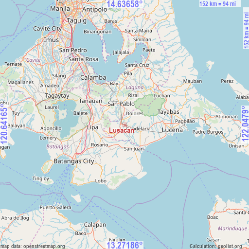
Lusacan GPS coordinates[2]
13° 57' 18.828" North, 121° 20' 41.172" East
| Map corner | latitude | longitude |
|---|---|---|
| Upper-left | 14.63658°, | 120.64165° |
| Center: | 13.95523°, | 121.34477° |
| Lower-right: | 13.27186°, | 122.0479° |
| Map W x H: | 151.7×151.7 km | = 94.3×94.3mi |
| max Lat: | 20.78733° ⇑31.6% North |
| Lusacan: | 13.95523° |
| min Lat: | ⇓68.4% South 4.65442° |
| min Long | Lusacan | max Long |
| 117.04868° | 121.34477° | 126.58417° |
| W 30.6%⇐ | ⇒69.4% E |
Elevation
Elevation of Lusacan is 52 m = 171 ft, and this is 35.9 m = 118 ft below average elevation for this country.
| Max E: |
2262 m = 7421 ft | 30% |
| Avg. | 87.9 m = 288 ft | |
| Lusacan | 52 m = 171 ft | |
Min E: |
-2 m = -7 ft | 70% |
See also: Philippines elevation on elevation.city.
Geographical zone
Lusacan is located in North Torrid zone (between Equator and Tropic of Cancer). Distance of this Northern Tropic circle is 1054.2 km =655 mi to North.| Distance of | km | miles | from Lusacan |
|---|---|---|---|
| North Pole | 8455.4 | 5253.9 | to North |
| Arctic Circle | 5849.5 | 3634.7 | to North |
| Tropic Cancer | 1054.2 | 655 | to North |
| Equator | 1551.7 | 964.2 | to South |


Nearby cities:
15 places around Lusacan: (largest is in red/bold)
• Ayusan Uno
4 km =2.5 mi,  271°
271°
• Bautista
8.4 km =5.2 mi,  301°
301°
• Bukal Sur
4.8 km =3 mi,  113°
113°
• Bungoy
5.2 km =3.2 mi,  25°
25°
• Cabatang
2.7 km =1.7 mi,  61°
61°
• Candelaria
8.9 km =5.5 mi, 107°
• Dagatan
6.2 km =3.9 mi, 33°
• Lalig
3.6 km =2.2 mi,  326°
326°
• Masalukot Uno
8 km =5 mi,  89°
89°
• Paiisa
3.4 km =2.1 mi,  162°
162°
• Quipot
2.8 km =1.7 mi, 270°
• San Antonio
8.8 km =5.5 mi,  222°
222°
• Santa Cruz
7.4 km =4.6 mi,  10°
10°
• Santisimo Rosario
6 km =3.7 mi,  320°
320°
• Tiaong
2.7 km =1.7 mi,  290°
290°
Sources, notices
• [Note1] Compared only with cities in Philippines existing in our database
• [Src1] Map data: © OpenStreetMap contributors (CC-BY-SA)
• [Src2] Other city data from geonames.org with taken over terms of usage.
• [Src3] Geographical zone / Annual Mean Temperature by Robert A. Rohde @ Wikipedia
