Montecillo geodata
Montecillo (Calabarzon) is a populated place; located in Philippines in Asia/Manila (GMT+8) time zone. With population of 3,289 people, there are 2226 cities with bigger population in this country. Compared to other cities in Philippines, 67.3% of cities are located further ↓South; 66.9% of cities are located further →East and 67.1% of cities have lower elevation than Montecillo. Note1


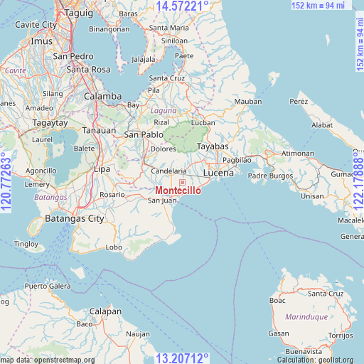
Montecillo GPS coordinates[2]
13° 53' 26.412" North, 121° 28' 32.7" East
| Map corner | latitude | longitude |
|---|---|---|
| Upper-left | 14.57221°, | 120.77263° |
| Center: | 13.89067°, | 121.47575° |
| Lower-right: | 13.20712°, | 122.17888° |
| Map W x H: | 151.8×151.8 km | = 94.3×94.3mi |
| max Lat: | 20.78733° ⇑32.7% North |
| Montecillo: | 13.89067° |
| min Lat: | ⇓67.3% South 4.65442° |
| min Long | Montecillo | max Long |
| 117.04868° | 121.47575° | 126.58417° |
| W 33.1%⇐ | ⇒66.9% E |
Elevation
Elevation of Montecillo is 46 m = 151 ft, and this is 41.9 m = 137 ft below average elevation for this country.
| Max E: |
2262 m = 7421 ft | 32.9% |
| Avg. | 87.9 m = 288 ft | |
| Montecillo | 46 m = 151 ft | |
Min E: |
-2 m = -7 ft | 67.1% |
See also: Philippines elevation on elevation.city.
Geographical zone
Montecillo is located in North Torrid zone (between Equator and Tropic of Cancer). Distance of this Northern Tropic circle is 1061.4 km =659.5 mi to North.| Distance of | km | miles | from Montecillo |
|---|---|---|---|
| North Pole | 8462.6 | 5258.4 | to North |
| Arctic Circle | 5856.7 | 3639.2 | to North |
| Tropic Cancer | 1061.4 | 659.5 | to North |
| Equator | 1544.5 | 959.7 | to South |


Nearby cities:
15 places around Montecillo: (largest is in red/bold)
• Bignay Uno
3.2 km =2 mi,  155°
155°
• Bukal
6 km =3.7 mi,  65°
65°
• Candelaria
7.2 km =4.5 mi,  308°
308°
• Castañas
8.6 km =5.3 mi,  102°
102°
• Concepcion Ibaba
3.9 km =2.4 mi,  336°
336°
• Guisguis
5 km =3.1 mi,  111°
111°
• Janagdong
4.3 km =2.7 mi, 70°
• Lipahan
10 km =6.2 mi,  233°
233°
• Malabanban Norte
7.8 km =4.8 mi,  321°
321°
• Masalukot Uno
9.5 km =5.9 mi, 319°
• Poctol
8.6 km =5.3 mi,  205°
205°
• San Juan
10.5 km =6.5 mi, 232°
• Santa Catalina Sur
5.2 km =3.2 mi,  248°
248°
• Sariaya
9.7 km =6 mi,  34°
34°
• Tipaz
8.8 km =5.5 mi,  218°
218°
Sources, notices
• [Note1] Compared only with cities in Philippines existing in our database
• [Src1] Map data: © OpenStreetMap contributors (CC-BY-SA)
• [Src2] Other city data from geonames.org with taken over terms of usage.
• [Src3] Geographical zone / Annual Mean Temperature by Robert A. Rohde @ Wikipedia
