San Pascual geodata
San Pascual (Central Visayas) is a populated place; located in Philippines in Asia/Manila (GMT+8) time zone. With population of 3,351 people, there are 2182 cities with bigger population in this country. Compared to other cities in Philippines, 68.7% of cities are located further ↑North; 77.9% of cities are located further ←West and 58.1% of cities have lower elevation than San Pascual. Note1


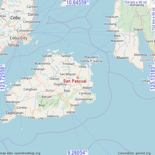
San Pascual GPS coordinates[2]
9° 57' 13.68" North, 124° 25' 43.32" East
| Map corner | latitude | longitude |
|---|---|---|
| Upper-left | 10.64559°, | 123.72558° |
| Center: | 9.9538°, | 124.4287° |
| Lower-right: | 9.26054°, | 125.13183° |
| Map W x H: | 154×154 km | = 95.7×95.7mi |
| max Lat: | 20.78733° ⇑68.7% North |
| San Pascual: | 9.9538° |
| min Lat: | ⇓31.3% South 4.65442° |
| min Long | San Pascual | max Long |
| 117.04868° | 124.4287° | 126.58417° |
| W 77.9%⇐ | ⇒22.1% E |
Elevation
Elevation of San Pascual is 31 m = 102 ft, and this is 56.9 m = 187 ft below average elevation for this country.
| Max E: |
2262 m = 7421 ft | 41.9% |
| Avg. | 87.9 m = 288 ft | |
| San Pascual | 31 m = 102 ft | |
Min E: |
-2 m = -7 ft | 58.1% |
See also: Philippines elevation on elevation.city.
Geographical zone
San Pascual is located in North Torrid zone (between Equator and Tropic of Cancer). Distance of Equator is 1106.8 km =687.7 mi to South.| Distance of | km | miles | from San Pascual |
|---|---|---|---|
| North Pole | 8900.3 | 5530.4 | to North |
| Arctic Circle | 6294.4 | 3911.2 | to North |
| Tropic Cancer | 1499.2 | 931.6 | to North |
| Equator | 1106.8 | 687.7 | to South |


Nearby cities:
15 places around San Pascual: (largest is in red/bold)
• Abaca
9.2 km =5.7 mi,  113°
113°
• Alicia
6.7 km =4.2 mi,  167°
167°
• Camambugan
11.7 km =7.3 mi,  5°
5°
• Candijay
16.9 km =10.5 mi,  153°
153°
• Hinlayagan Ilaud
13.4 km =8.3 mi,  309°
309°
• La Hacienda
9 km =5.6 mi,  206°
206°
• Mabini
14.2 km =8.8 mi,  134°
134°
• Mahayag
12.5 km =7.8 mi,  260°
260°
• San Miguel
10.3 km =6.4 mi,  290°
290°
• San Miguel
13.6 km =8.5 mi,  235°
235°
• Tagum Norte
14.1 km =8.8 mi,  342°
342°
• Tipolo
11.9 km =7.4 mi,  52°
52°
• Trinidad
16.8 km =10.4 mi,  326°
326°
• Ubay
12.4 km =7.7 mi,  23°
23°
• Union
14.1 km =8.8 mi,  42°
42°
Sources, notices
• [Note1] Compared only with cities in Philippines existing in our database
• [Src1] Map data: © OpenStreetMap contributors (CC-BY-SA)
• [Src2] Other city data from geonames.org with taken over terms of usage.
• [Src3] Geographical zone / Annual Mean Temperature by Robert A. Rohde @ Wikipedia
