Mabalacat City geodata
Mabalacat City (Central Luzon) is a seat of a third-order administrative division; located in Philippines in Asia/Manila (GMT+8) time zone. With population of 188,050 people, there are 56 cities with bigger population in this country. Compared to other cities in Philippines, 79.4% of cities are located further ↓South; 89% of cities are located further →East and 82.3% of cities have lower elevation than Mabalacat City. Note1
Administrative division(s):
- Level 1: Central Luzon
- Level 2: Province of Pampanga
- Level 3: Mabalacat City


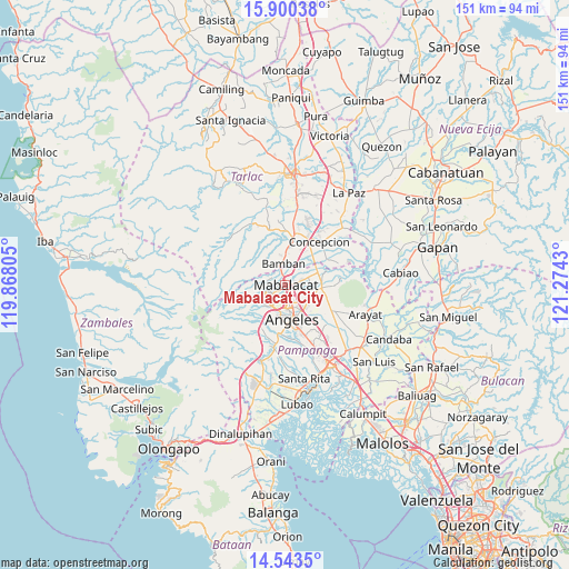
Mabalacat City GPS coordinates[2]
15° 13' 22.908" North, 120° 34' 16.212" East
| Map corner | latitude | longitude |
|---|---|---|
| Upper-left | 15.90038°, | 119.86805° |
| Center: | 15.22303°, | 120.57117° |
| Lower-right: | 14.5435°, | 121.2743° |
| Map W x H: | 150.9×150.9 km | = 93.8×93.8mi |
| max Lat: | 20.78733° ⇑20.6% North |
| Mabalacat City: | 15.22303° |
| min Lat: | ⇓79.4% South 4.65442° |
| min Long | Mabalacat City | max Long |
| 117.04868° | 120.57117° | 126.58417° |
| W 11%⇐ | ⇒89% E |
Elevation
Elevation of Mabalacat City is 109 m = 358 ft, and this is 21.1 m = 69 ft above average elevation for this country.
| Max E: |
2262 m = 7421 ft | 17.7% |
| Mabalacat City | 109 m 358 ft | |
| Avg. | 87.9 m = 288 ft | |
Min E: |
-2 m = -7 ft | 82.3% |
See also: Mabalacat City elevation on elevation.city.
Geographical zone
Mabalacat City is located in North Torrid zone (between Equator and Tropic of Cancer). Distance of this Northern Tropic circle is 913.3 km =567.5 mi to North.| Distance of | km | miles | from Mabalacat City |
|---|---|---|---|
| North Pole | 8314.4 | 5166.3 | to North |
| Arctic Circle | 5708.5 | 3547.1 | to North |
| Tropic Cancer | 913.3 | 567.5 | to North |
| Equator | 1692.6 | 1051.7 | to South |


Nearby cities:
15 places around Mabalacat City: (largest is in red/bold)
• Angeles City
8.2 km =5.1 mi,  170°
170°
• Balibago
7.2 km =4.5 mi,  158°
158°
• Buensuseso
11.4 km =7.1 mi,  106°
106°
• Calibutbut
12.4 km =7.7 mi, 166°
• Calingcuan
12.3 km =7.6 mi,  6°
6°
• Capas
12.2 km =7.6 mi, 9°
• Culubasa
12.3 km =7.6 mi,  135°
135°
• Magalang
9.5 km =5.9 mi,  95°
95°
• Pandacaqui
10.6 km =6.6 mi,  122°
122°
• San Isidro
7.6 km =4.7 mi,  79°
79°
• San Roque
9.7 km =6 mi,  63°
63°
• San Vicente
11.8 km =7.3 mi,  49°
49°
• Santol
6.8 km =4.2 mi,  183°
183°
• Tal I Mun Doc
12.3 km =7.6 mi, 95°
• Telabastagan
12.3 km =7.6 mi, 161°
Sources, notices
• [Note1] Compared only with cities in Philippines existing in our database
• [Src1] Map data: © OpenStreetMap contributors (CC-BY-SA)
• [Src2] Other city data from geonames.org with taken over terms of usage.
• [Src3] Geographical zone / Annual Mean Temperature by Robert A. Rohde @ Wikipedia
