Calibutbut geodata
Calibutbut (Central Luzon) is a populated place; located in Philippines in Asia/Manila (GMT+8) time zone. With population of 5,282 people, there are 1207 cities with bigger population in this country. Compared to other cities in Philippines, 78.6% of cities are located further ↓South; 88.1% of cities are located further →East and 77.7% of cities have lower elevation than Calibutbut. Note1


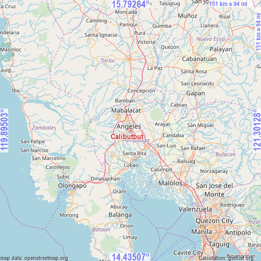
Calibutbut GPS coordinates[2]
15° 6' 53.784" North, 120° 35' 53.34" East
| Map corner | latitude | longitude |
|---|---|---|
| Upper-left | 15.79264°, | 119.89503° |
| Center: | 15.11494°, | 120.59815° |
| Lower-right: | 14.43507°, | 121.30128° |
| Map W x H: | 150.9×151 km | = 93.8×93.8mi |
| max Lat: | 20.78733° ⇑21.4% North |
| Calibutbut: | 15.11494° |
| min Lat: | ⇓78.6% South 4.65442° |
| min Long | Calibutbut | max Long |
| 117.04868° | 120.59815° | 126.58417° |
| W 11.9%⇐ | ⇒88.1% E |
Elevation
Elevation of Calibutbut is 79 m = 259 ft, and this is 8.9 m = 29 ft below average elevation for this country.
| Max E: |
2262 m = 7421 ft | 22.3% |
| Avg. | 87.9 m = 288 ft | |
| Calibutbut | 79 m = 259 ft | |
Min E: |
-2 m = -7 ft | 77.7% |
See also: Philippines elevation on elevation.city.
Geographical zone
Calibutbut is located in North Torrid zone (between Equator and Tropic of Cancer). Distance of this Northern Tropic circle is 925.3 km =575 mi to North.| Distance of | km | miles | from Calibutbut |
|---|---|---|---|
| North Pole | 8326.4 | 5173.8 | to North |
| Arctic Circle | 5720.6 | 3554.6 | to North |
| Tropic Cancer | 925.3 | 575 | to North |
| Equator | 1680.6 | 1044.3 | to South |


Nearby cities:
15 places around Calibutbut: (largest is in red/bold)
• Acli
5.1 km =3.2 mi,  80°
80°
• Angeles City
4.2 km =2.6 mi,  337°
337°
• Balas
7.3 km =4.5 mi,  190°
190°
• Balibago
5.3 km =3.3 mi,  356°
356°
• Bulaon
7.8 km =4.8 mi,  117°
117°
• Cauayan
8.9 km =5.5 mi,  62°
62°
• Culubasa
6.7 km =4.2 mi, 60°
• Dolores
7.8 km =4.8 mi,  253°
253°
• Malino
8.3 km =5.2 mi, 80°
• Manibaug Pasig
4.2 km =2.6 mi,  240°
240°
• Pandacaqui
8.8 km =5.5 mi,  43°
43°
• Porac
7.7 km =4.8 mi,  230°
230°
• Pulung Santol
8.6 km =5.3 mi,  206°
206°
• Santol
6.2 km =3.9 mi,  327°
327°
• Telabastagan
1.1 km =0.7 mi,  68°
68°
Sources, notices
• [Note1] Compared only with cities in Philippines existing in our database
• [Src1] Map data: © OpenStreetMap contributors (CC-BY-SA)
• [Src2] Other city data from geonames.org with taken over terms of usage.
• [Src3] Geographical zone / Annual Mean Temperature by Robert A. Rohde @ Wikipedia
