Balibago geodata
Balibago (Central Luzon) is a populated place; located in Philippines in Asia/Manila (GMT+8) time zone. With population of 5,057 people, there are 1275 cities with bigger population in this country. Compared to other cities in Philippines, 79% of cities are located further ↓South; 88.3% of cities are located further →East and 80.7% of cities have lower elevation than Balibago. Note1
Administrative division(s):
- Level 1: Central Luzon
- Level 2: Province of Pampanga
- Level 3: Angeles City


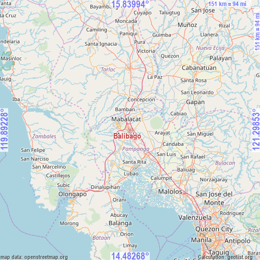
Balibago GPS coordinates[2]
15° 9' 44.64" North, 120° 35' 43.44" East
| Map corner | latitude | longitude |
|---|---|---|
| Upper-left | 15.83994°, | 119.89228° |
| Center: | 15.1624°, | 120.5954° |
| Lower-right: | 14.48268°, | 121.29853° |
| Map W x H: | 150.9×150.9 km | = 93.8×93.8mi |
| max Lat: | 20.78733° ⇑21% North |
| Balibago: | 15.1624° |
| min Lat: | ⇓79% South 4.65442° |
| min Long | Balibago | max Long |
| 117.04868° | 120.5954° | 126.58417° |
| W 11.7%⇐ | ⇒88.3% E |
Elevation
Elevation of Balibago is 96 m = 315 ft, and this is 8.1 m = 27 ft above average elevation for this country.
| Max E: |
2262 m = 7421 ft | 19.3% |
| Balibago | 96 m 315 ft | |
| Avg. | 87.9 m = 288 ft | |
Min E: |
-2 m = -7 ft | 80.7% |
See also: Philippines elevation on elevation.city.
Geographical zone
Balibago is located in North Torrid zone (between Equator and Tropic of Cancer). Distance of this Northern Tropic circle is 920 km =571.7 mi to North.| Distance of | km | miles | from Balibago |
|---|---|---|---|
| North Pole | 8321.2 | 5170.6 | to North |
| Arctic Circle | 5715.3 | 3551.3 | to North |
| Tropic Cancer | 920 | 571.7 | to North |
| Equator | 1685.9 | 1047.6 | to South |


Nearby cities:
15 places around Balibago: (largest is in red/bold)
• Acli
6.9 km =4.3 mi,  129°
129°
• Angeles City
1.9 km =1.2 mi,  223°
223°
• Arenas
9.7 km =6 mi,  84°
84°
• Buensuseso
9 km =5.6 mi,  67°
67°
• Calibutbut
5.3 km =3.3 mi,  176°
176°
• Cauayan
8.3 km =5.2 mi,  98°
98°
• Culubasa
6.4 km =4 mi,  108°
108°
• Mabalacat City
7.2 km =4.5 mi,  338°
338°
• Magalang
9 km =5.6 mi,  49°
49°
• Malino
9.3 km =5.8 mi, 114°
• Manibaug Pasig
8.1 km =5 mi,  204°
204°
• Pandacaqui
6.4 km =4 mi, 80°
• San Isidro
9.5 km =5.9 mi,  31°
31°
• Santol
3 km =1.9 mi,  269°
269°
• Telabastagan
5.1 km =3.2 mi,  164°
164°
Sources, notices
• [Note1] Compared only with cities in Philippines existing in our database
• [Src1] Map data: © OpenStreetMap contributors (CC-BY-SA)
• [Src2] Other city data from geonames.org with taken over terms of usage.
• [Src3] Geographical zone / Annual Mean Temperature by Robert A. Rohde @ Wikipedia
