Maasin geodata
Maasin (Western Visayas) is a seat of a third-order administrative division; located in Philippines in Asia/Manila (GMT+8) time zone. With population of 3,514 people, there are 2045 cities with bigger population in this country. Compared to other cities in Philippines, 58.2% of cities are located further ↑North; 55.7% of cities are located further →East and 78.7% of cities have lower elevation than Maasin. Note1


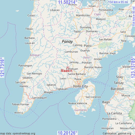
Maasin GPS coordinates[2]
10° 53' 33" North, 122° 26' 4.992" East
| Map corner | latitude | longitude |
|---|---|---|
| Upper-left | 11.58214°, | 121.7316° |
| Center: | 10.8925°, | 122.43472° |
| Lower-right: | 10.20126°, | 123.13785° |
| Map W x H: | 153.5×153.5 km | = 95.4×95.4mi |
| max Lat: | 20.78733° ⇑58.2% North |
| Maasin: | 10.8925° |
| min Lat: | ⇓41.8% South 4.65442° |
| min Long | Maasin | max Long |
| 117.04868° | 122.43472° | 126.58417° |
| W 44.3%⇐ | ⇒55.7% E |
Elevation
Elevation of Maasin is 84 m = 276 ft, and this is 3.9 m = 13 ft below average elevation for this country.
| Max E: |
2262 m = 7421 ft | 21.3% |
| Avg. | 87.9 m = 288 ft | |
| Maasin | 84 m = 276 ft | |
Min E: |
-2 m = -7 ft | 78.7% |
See also: Philippines elevation on elevation.city.
Geographical zone
Maasin is located in North Torrid zone (between Equator and Tropic of Cancer). Distance of Equator is 1211.1 km =752.5 mi to South.| Distance of | km | miles | from Maasin |
|---|---|---|---|
| North Pole | 8795.9 | 5465.5 | to North |
| Arctic Circle | 6190 | 3846.3 | to North |
| Tropic Cancer | 1394.8 | 866.7 | to North |
| Equator | 1211.1 | 752.5 | to South |


Nearby cities:
15 places around Maasin: (largest is in red/bold)
• Alimodian
7.9 km =4.9 mi,  182°
182°
• Badiangan
14.5 km =9 mi,  29°
29°
• Balibagan Oeste
13.6 km =8.5 mi,  138°
138°
• Bolong
12.3 km =7.6 mi,  133°
133°
• Cabatuan
5.8 km =3.6 mi,  104°
104°
• Cabugao
15.1 km =9.4 mi, 127°
• Cadagmayan Norte
11 km =6.8 mi, 139°
• Gines-Patay
8 km =5 mi,  53°
53°
• Janiuay
10 km =6.2 mi, 50°
• Jibao-an
14.1 km =8.8 mi,  149°
149°
• Leon
13.4 km =8.3 mi,  201°
201°
• San Antonio
10.4 km =6.5 mi,  170°
170°
• San Miguel
13 km =8.1 mi,  164°
164°
• Santa Barbara
13.3 km =8.3 mi, 125°
• Tiring
9.2 km =5.7 mi,  121°
121°
Sources, notices
• [Note1] Compared only with cities in Philippines existing in our database
• [Src1] Map data: © OpenStreetMap contributors (CC-BY-SA)
• [Src2] Other city data from geonames.org with taken over terms of usage.
• [Src3] Geographical zone / Annual Mean Temperature by Robert A. Rohde @ Wikipedia
