Janiuay geodata
Janiuay (Western Visayas) is a seat of a third-order administrative division; located in Philippines in Asia/Manila (GMT+8) time zone. With population of 12,896 people, there are 496 cities with bigger population in this country. Compared to other cities in Philippines, 57.4% of cities are located further ↑North; 54.7% of cities are located further →East and 74.3% of cities have lower elevation than Janiuay. Note1


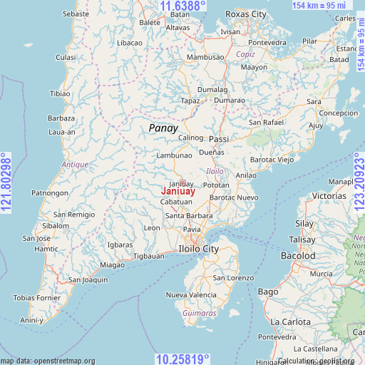
Janiuay GPS coordinates[2]
10° 56' 57.48" North, 122° 30' 21.96" East
| Map corner | latitude | longitude |
|---|---|---|
| Upper-left | 11.6388°, | 121.80298° |
| Center: | 10.9493°, | 122.5061° |
| Lower-right: | 10.25819°, | 123.20923° |
| Map W x H: | 153.5×153.5 km | = 95.4×95.4mi |
| max Lat: | 20.78733° ⇑57.4% North |
| Janiuay: | 10.9493° |
| min Lat: | ⇓42.6% South 4.65442° |
| min Long | Janiuay | max Long |
| 117.04868° | 122.5061° | 126.58417° |
| W 45.3%⇐ | ⇒54.7% E |
Elevation
Elevation of Janiuay is 66 m = 217 ft, and this is 21.9 m = 72 ft below average elevation for this country.
| Max E: |
2262 m = 7421 ft | 25.7% |
| Avg. | 87.9 m = 288 ft | |
| Janiuay | 66 m = 217 ft | |
Min E: |
-2 m = -7 ft | 74.3% |
See also: Philippines elevation on elevation.city.
Geographical zone
Janiuay is located in North Torrid zone (between Equator and Tropic of Cancer). Distance of Equator is 1217.4 km =756.5 mi to South.| Distance of | km | miles | from Janiuay |
|---|---|---|---|
| North Pole | 8789.6 | 5461.6 | to North |
| Arctic Circle | 6183.7 | 3842.4 | to North |
| Tropic Cancer | 1388.5 | 862.8 | to North |
| Equator | 1217.4 | 756.5 | to South |


Nearby cities:
15 places around Janiuay: (largest is in red/bold)
• Badiangan
6.3 km =3.9 mi,  354°
354°
• Binabaan
8 km =5 mi,  12°
12°
• Bolong
14.8 km =9.2 mi,  175°
175°
• Cabatuan
8.1 km =5 mi,  195°
195°
• Cadagmayan Norte
14.8 km =9.2 mi, 182°
• Gines-Patay
2.1 km =1.3 mi,  222°
222°
• Jamabalod
14.8 km =9.2 mi,  121°
121°
• Kabilauan
12.3 km =7.6 mi,  143°
143°
• Lambunao
12.3 km =7.6 mi,  344°
344°
• Lucena
12.6 km =7.8 mi,  128°
128°
• Maasin
10 km =6.2 mi,  230°
230°
• Mina
7.7 km =4.8 mi,  105°
105°
• Pototan
14.1 km =8.8 mi,  92°
92°
• Santa Barbara
14.4 km =8.9 mi,  167°
167°
• Tiring
11 km =6.8 mi, 179°
Sources, notices
• [Note1] Compared only with cities in Philippines existing in our database
• [Src1] Map data: © OpenStreetMap contributors (CC-BY-SA)
• [Src2] Other city data from geonames.org with taken over terms of usage.
• [Src3] Geographical zone / Annual Mean Temperature by Robert A. Rohde @ Wikipedia
