Gines-Patay geodata
Gines-Patay (Western Visayas) is a populated place; located in Philippines in Asia/Manila (GMT+8) time zone. With population of 2,476 people, there are 3337 cities with bigger population in this country. Compared to other cities in Philippines, 57.6% of cities are located further ↑North; 55% of cities are located further →East and 84.6% of cities have lower elevation than Gines-Patay. Note1


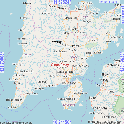
Gines-Patay GPS coordinates[2]
10° 56' 8.52" North, 122° 29' 35.52" East
| Map corner | latitude | longitude |
|---|---|---|
| Upper-left | 11.62524°, | 121.79008° |
| Center: | 10.9357°, | 122.4932° |
| Lower-right: | 10.24456°, | 123.19633° |
| Map W x H: | 153.5×153.5 km | = 95.4×95.4mi |
| max Lat: | 20.78733° ⇑57.6% North |
| Gines-Patay: | 10.9357° |
| min Lat: | ⇓42.4% South 4.65442° |
| min Long | Gines-Patay | max Long |
| 117.04868° | 122.4932° | 126.58417° |
| W 45%⇐ | ⇒55% E |
Elevation
Elevation of Gines-Patay is 131 m = 430 ft, and this is 43.1 m = 141 ft above average elevation for this country.
| Max E: |
2262 m = 7421 ft | 15.4% |
| Gines-Patay | 131 m 430 ft | |
| Avg. | 87.9 m = 288 ft | |
Min E: |
-2 m = -7 ft | 84.6% |
See also: Philippines elevation on elevation.city.
Geographical zone
Gines-Patay is located in North Torrid zone (between Equator and Tropic of Cancer). Distance of Equator is 1215.9 km =755.5 mi to South.| Distance of | km | miles | from Gines-Patay |
|---|---|---|---|
| North Pole | 8791.1 | 5462.5 | to North |
| Arctic Circle | 6185.2 | 3843.3 | to North |
| Tropic Cancer | 1390 | 863.7 | to North |
| Equator | 1215.9 | 755.5 | to South |


Nearby cities:
15 places around Gines-Patay: (largest is in red/bold)
• Alimodian
14.4 km =8.9 mi,  208°
208°
• Badiangan
7.8 km =4.8 mi,  5°
5°
• Binabaan
9.8 km =6.1 mi,  18°
18°
• Bolong
13.5 km =8.4 mi,  169°
169°
• Cabatuan
6.3 km =3.9 mi,  187°
187°
• Cabugao
15 km =9.3 mi,  158°
158°
• Cadagmayan Norte
13.3 km =8.3 mi,  176°
176°
• Janiuay
2.1 km =1.3 mi,  42°
42°
• Kabilauan
12.1 km =7.5 mi,  133°
133°
• Lambunao
13.5 km =8.4 mi,  351°
351°
• Lucena
12.9 km =8 mi,  118°
118°
• Maasin
8 km =5 mi,  233°
233°
• Mina
8.9 km =5.5 mi,  93°
93°
• Santa Barbara
13.3 km =8.3 mi, 160°
• Tiring
9.6 km =6 mi, 171°
Sources, notices
• [Note1] Compared only with cities in Philippines existing in our database
• [Src1] Map data: © OpenStreetMap contributors (CC-BY-SA)
• [Src2] Other city data from geonames.org with taken over terms of usage.
• [Src3] Geographical zone / Annual Mean Temperature by Robert A. Rohde @ Wikipedia
