Leon geodata
Leon (Western Visayas) is a seat of a third-order administrative division; located in Philippines in Asia/Manila (GMT+8) time zone. With population of 5,172 people, there are 1239 cities with bigger population in this country. Compared to other cities in Philippines, 59.8% of cities are located further ↑North; 56.3% of cities are located further →East and 74.9% of cities have lower elevation than Leon. Note1


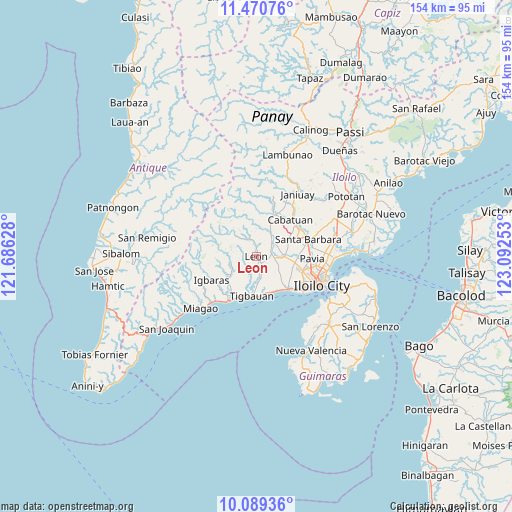
Leon GPS coordinates[2]
10° 46' 51.06" North, 122° 23' 21.84" East
| Map corner | latitude | longitude |
|---|---|---|
| Upper-left | 11.47076°, | 121.68628° |
| Center: | 10.78085°, | 122.3894° |
| Lower-right: | 10.08936°, | 123.09253° |
| Map W x H: | 153.6×153.6 km | = 95.4×95.4mi |
| max Lat: | 20.78733° ⇑59.8% North |
| Leon: | 10.78085° |
| min Lat: | ⇓40.2% South 4.65442° |
| min Long | Leon | max Long |
| 117.04868° | 122.3894° | 126.58417° |
| W 43.7%⇐ | ⇒56.3% E |
Elevation
Elevation of Leon is 68 m = 223 ft, and this is 19.9 m = 65 ft below average elevation for this country.
| Max E: |
2262 m = 7421 ft | 25.1% |
| Avg. | 87.9 m = 288 ft | |
| Leon | 68 m = 223 ft | |
Min E: |
-2 m = -7 ft | 74.9% |
See also: Philippines elevation on elevation.city.
Geographical zone
Leon is located in North Torrid zone (between Equator and Tropic of Cancer). Distance of Equator is 1198.7 km =744.8 mi to South.| Distance of | km | miles | from Leon |
|---|---|---|---|
| North Pole | 8808.3 | 5473.2 | to North |
| Arctic Circle | 6202.5 | 3854.1 | to North |
| Tropic Cancer | 1407.2 | 874.4 | to North |
| Equator | 1198.7 | 744.8 | to South |


Nearby cities:
15 places around Leon: (largest is in red/bold)
• Alimodian
6.4 km =4 mi,  45°
45°
• Atabayan
11.2 km =7 mi,  164°
164°
• Balabag
11.5 km =7.1 mi,  99°
99°
• Buray
10.6 km =6.6 mi,  133°
133°
• Buyuan
12.7 km =7.9 mi,  195°
195°
• Cadagmayan Norte
12.7 km =7.9 mi,  71°
71°
• Cordova
5.8 km =3.6 mi,  166°
166°
• Jibao-an
12.1 km =7.5 mi,  88°
88°
• Napnapan
8.1 km =5 mi,  177°
177°
• San Antonio
7 km =4.3 mi, 72°
• San Miguel
8.3 km =5.2 mi, 90°
• Santa Monica
8.6 km =5.3 mi, 125°
• Tigbauan
11.9 km =7.4 mi,  186°
186°
• Trapiche
11.7 km =7.3 mi, 156°
• Tubungan
8.1 km =5 mi,  256°
256°
Sources, notices
• [Note1] Compared only with cities in Philippines existing in our database
• [Src1] Map data: © OpenStreetMap contributors (CC-BY-SA)
• [Src2] Other city data from geonames.org with taken over terms of usage.
• [Src3] Geographical zone / Annual Mean Temperature by Robert A. Rohde @ Wikipedia
