Ambuclao geodata
Ambuclao (Cordillera) is a populated place; located in Philippines in Asia/Manila (GMT+8) time zone. With population of 2,822 people, there are 2754 cities with bigger population in this country. Compared to other cities in Philippines, 90.8% of cities are located further ↓South; 83.7% of cities are located further →East and 98.2% of cities have lower elevation than Ambuclao. Note1


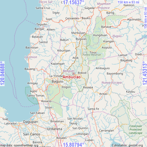
Ambuclao GPS coordinates[2]
16° 28' 59.988" North, 120° 45' 0" East
| Map corner | latitude | longitude |
|---|---|---|
| Upper-left | 17.15637°, | 120.04688° |
| Center: | 16.48333°, | 120.75° |
| Lower-right: | 15.80794°, | 121.45313° |
| Map W x H: | 149.9×149.9 km | = 93.1×93.1mi |
| max Lat: | 20.78733° ⇑9.2% North |
| Ambuclao: | 16.48333° |
| min Lat: | ⇓90.8% South 4.65442° |
| min Long | Ambuclao | max Long |
| 117.04868° | 120.75° | 126.58417° |
| W 16.3%⇐ | ⇒83.7% E |
Elevation
Elevation of Ambuclao is 761 m = 2497 ft, and this is 673.1 m = 2208 ft above average elevation for this country.
| Max E: |
2262 m = 7421 ft | 1.8% |
| Ambuclao | 761 m 2497 ft | |
| Avg. | 87.9 m = 288 ft | |
Min E: |
-2 m = -7 ft | 98.2% |
See also: Philippines elevation on elevation.city.
Geographical zone
Ambuclao is located in North Torrid zone (between Equator and Tropic of Cancer). Distance of this Northern Tropic circle is 773.1 km =480.4 mi to North.| Distance of | km | miles | from Ambuclao |
|---|---|---|---|
| North Pole | 8174.3 | 5079.3 | to North |
| Arctic Circle | 5568.4 | 3460 | to North |
| Tropic Cancer | 773.1 | 480.4 | to North |
| Equator | 1832.8 | 1138.8 | to South |


Nearby cities:
15 places around Ambuclao: (largest is in red/bold)
• Amlimay
25.2 km =15.7 mi,  21°
21°
• Atok
12.4 km =7.7 mi,  334°
334°
• Baguio
18.3 km =11.4 mi,  246°
246°
• Bokod
8.7 km =5.4 mi,  85°
85°
• Dalupirip
17.7 km =11 mi,  188°
188°
• Itogon
15.4 km =9.6 mi,  210°
210°
• Kabayan
18.3 km =11.4 mi,  31°
31°
• Kapangan
19.2 km =11.9 mi,  301°
301°
• Kayapa
20.1 km =12.5 mi,  133°
133°
• La Trinidad
17.6 km =10.9 mi,  259°
259°
• Loacan
11.6 km =7.2 mi,  309°
309°
• Natubleng
23.9 km =14.9 mi,  7°
7°
• Topdac
9 km =5.6 mi, 332°
• Tublay
16.4 km =10.2 mi,  293°
293°
• Tuding
14 km =8.7 mi,  234°
234°
Sources, notices
• [Note1] Compared only with cities in Philippines existing in our database
• [Src1] Map data: © OpenStreetMap contributors (CC-BY-SA)
• [Src2] Other city data from geonames.org with taken over terms of usage.
• [Src3] Geographical zone / Annual Mean Temperature by Robert A. Rohde @ Wikipedia
