Lubao geodata
Lubao (Central Luzon) is a seat of a third-order administrative division; located in Philippines in Asia/Manila (GMT+8) time zone. With population of 55,645 people, there are 166 cities with bigger population in this country. Compared to other cities in Philippines, 76.8% of cities are located further ↓South; 88% of cities are located further →East and 73.2% of cities have higher elevation than Lubao. Note1


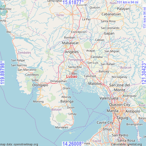
Lubao GPS coordinates[2]
14° 56' 25.8" North, 120° 36' 3.96" East
| Map corner | latitude | longitude |
|---|---|---|
| Upper-left | 15.61877°, | 119.89798° |
| Center: | 14.9405°, | 120.6011° |
| Lower-right: | 14.26008°, | 121.30423° |
| Map W x H: | 151.1×151.1 km | = 93.9×93.9mi |
| max Lat: | 20.78733° ⇑23.2% North |
| Lubao: | 14.9405° |
| min Lat: | ⇓76.8% South 4.65442° |
| min Long | Lubao | max Long |
| 117.04868° | 120.6011° | 126.58417° |
| W 12%⇐ | ⇒88% E |
Elevation
Elevation of Lubao is 11 m = 36 ft, and this is 76.9 m = 252 ft below average elevation for this country.
| Max E: |
2262 m = 7421 ft | 73.2% |
| Avg. | 87.9 m = 288 ft | |
| Lubao | 11 m = 36 ft | |
Min E: |
-2 m = -7 ft | 26.8% |
See also: Lubao elevation on elevation.city.
Geographical zone
Lubao is located in North Torrid zone (between Equator and Tropic of Cancer). Distance of this Northern Tropic circle is 944.7 km =587 mi to North.| Distance of | km | miles | from Lubao |
|---|---|---|---|
| North Pole | 8345.8 | 5185.8 | to North |
| Arctic Circle | 5739.9 | 3566.6 | to North |
| Tropic Cancer | 944.7 | 587 | to North |
| Equator | 1661.2 | 1032.2 | to South |


Nearby cities:
15 places around Lubao: (largest is in red/bold)
• Bacolor
8.6 km =5.3 mi,  39°
39°
• Calangain
6.5 km =4 mi,  224°
224°
• Floridablanca
8.8 km =5.5 mi,  297°
297°
• Guagua
4.4 km =2.7 mi,  50°
50°
• Maquiapo
6.8 km =4.2 mi,  317°
317°
• Pulungmasle
8.1 km =5 mi,  325°
325°
• San Agustin
5.6 km =3.5 mi,  5°
5°
• San Antonio
3.1 km =1.9 mi,  21°
21°
• San Francisco
6.4 km =4 mi,  291°
291°
• San Roque Dau First
4.8 km =3 mi, 327°
• Santa Cruz
4.8 km =3 mi,  230°
230°
• Santa Rita
6.6 km =4.1 mi, 9°
• Santa Teresa First
4.9 km =3 mi,  251°
251°
• Santo Domingo
5.5 km =3.4 mi, 300°
• Sexmoan
2.4 km =1.5 mi,  81°
81°
Sources, notices
• [Note1] Compared only with cities in Philippines existing in our database
• [Src1] Map data: © OpenStreetMap contributors (CC-BY-SA)
• [Src2] Other city data from geonames.org with taken over terms of usage.
• [Src3] Geographical zone / Annual Mean Temperature by Robert A. Rohde @ Wikipedia
