Calangain geodata
Calangain (Central Luzon) is a populated place; located in Philippines in Asia/Manila (GMT+8) time zone. With population of 2,526 people, there are 3249 cities with bigger population in this country. Compared to other cities in Philippines, 76.4% of cities are located further ↓South; 89.4% of cities are located further →East and 92.7% of cities have higher elevation than Calangain. Note1


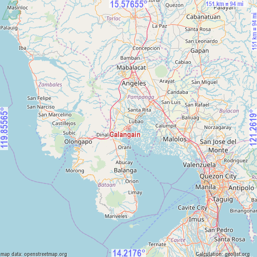
Calangain GPS coordinates[2]
14° 53' 53.34" North, 120° 33' 31.572" East
| Map corner | latitude | longitude |
|---|---|---|
| Upper-left | 15.57655°, | 119.85565° |
| Center: | 14.89815°, | 120.55877° |
| Lower-right: | 14.2176°, | 121.2619° |
| Map W x H: | 151.1×151.1 km | = 93.9×93.9mi |
| max Lat: | 20.78733° ⇑23.6% North |
| Calangain: | 14.89815° |
| min Lat: | ⇓76.4% South 4.65442° |
| min Long | Calangain | max Long |
| 117.04868° | 120.55877° | 126.58417° |
| W 10.6%⇐ | ⇒89.4% E |
Elevation
Elevation of Calangain is 6 m = 20 ft, and this is 81.9 m = 269 ft below average elevation for this country.
| Max E: |
2262 m = 7421 ft | 92.7% |
| Avg. | 87.9 m = 288 ft | |
| Calangain | 6 m = 20 ft | |
Min E: |
-2 m = -7 ft | 7.3% |
See also: Philippines elevation on elevation.city.
Geographical zone
Calangain is located in North Torrid zone (between Equator and Tropic of Cancer). Distance of this Northern Tropic circle is 949.4 km =589.9 mi to North.| Distance of | km | miles | from Calangain |
|---|---|---|---|
| North Pole | 8350.5 | 5188.8 | to North |
| Arctic Circle | 5744.7 | 3569.6 | to North |
| Tropic Cancer | 949.4 | 589.9 | to North |
| Equator | 1656.5 | 1029.3 | to South |


Nearby cities:
15 places around Calangain: (largest is in red/bold)
• Balsic
9.3 km =5.8 mi,  242°
242°
• Bodega
8.9 km =5.5 mi,  287°
287°
• Floridablanca
9.4 km =5.8 mi,  339°
339°
• Gutad
8.1 km =5 mi, 293°
• Hermosa
9.2 km =5.7 mi,  216°
216°
• Lubao
6.5 km =4 mi,  44°
44°
• Malusac
8 km =5 mi,  123°
123°
• Prado Siongco
5.4 km =3.4 mi,  246°
246°
• San Francisco
7.2 km =4.5 mi,  348°
348°
• San Roque Dau First
9 km =5.6 mi,  12°
12°
• Santa Cruz
1.8 km =1.1 mi,  27°
27°
• Santa Teresa First
3.2 km =2 mi,  358°
358°
• Santiago
5.1 km =3.2 mi,  276°
276°
• Santo Domingo
7.5 km =4.7 mi, 358°
• Sexmoan
8.6 km =5.3 mi,  53°
53°
Sources, notices
• [Note1] Compared only with cities in Philippines existing in our database
• [Src1] Map data: © OpenStreetMap contributors (CC-BY-SA)
• [Src2] Other city data from geonames.org with taken over terms of usage.
• [Src3] Geographical zone / Annual Mean Temperature by Robert A. Rohde @ Wikipedia
