Luba geodata
Luba (Cordillera) is a seat of a third-order administrative division; located in Philippines in Asia/Manila (GMT+8) time zone. In our database, there are 4166 cities with bigger population. Compared to other cities in Philippines, 95.2% of cities are located further ↓South; 85% of cities are located further →East and 87.6% of cities have lower elevation than Luba. Note1


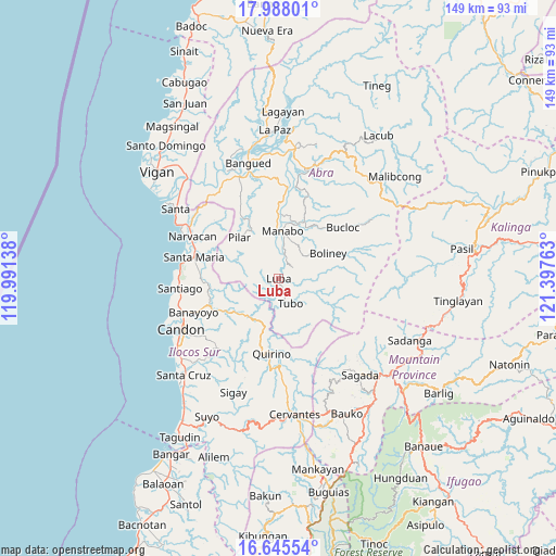
Luba GPS coordinates[2]
17° 19' 4.8" North, 120° 41' 40.2" East
| Map corner | latitude | longitude |
|---|---|---|
| Upper-left | 17.98801°, | 119.99138° |
| Center: | 17.318°, | 120.6945° |
| Lower-right: | 16.64554°, | 121.39763° |
| Map W x H: | 149.3×149.3 km | = 92.8×92.8mi |
| max Lat: | 20.78733° ⇑4.8% North |
| Luba: | 17.318° |
| min Lat: | ⇓95.2% South 4.65442° |
| min Long | Luba | max Long |
| 117.04868° | 120.6945° | 126.58417° |
| W 15%⇐ | ⇒85% E |
Elevation
Elevation of Luba is 175 m = 574 ft, and this is 87.1 m = 286 ft above average elevation for this country.
| Max E: |
2262 m = 7421 ft | 12.4% |
| Luba | 175 m 574 ft | |
| Avg. | 87.9 m = 288 ft | |
Min E: |
-2 m = -7 ft | 87.6% |
See also: Philippines elevation on elevation.city.
Geographical zone
Luba is located in North Torrid zone (between Equator and Tropic of Cancer). Distance of this Northern Tropic circle is 680.3 km =422.7 mi to North.| Distance of | km | miles | from Luba |
|---|---|---|---|
| North Pole | 8081.5 | 5021.6 | to North |
| Arctic Circle | 5475.6 | 3402.4 | to North |
| Tropic Cancer | 680.3 | 422.7 | to North |
| Equator | 1925.6 | 1196.5 | to South |


Nearby cities:
15 places around Luba: (largest is in red/bold)
• Bantay
14.9 km =9.3 mi,  26°
26°
• Boliney
13.6 km =8.5 mi,  42°
42°
• Bucloc
22.2 km =13.8 mi,  51°
51°
• Burgos
21.2 km =13.2 mi,  274°
274°
• Gregorio del Pilar
22.6 km =14 mi,  202°
202°
• Lidlidda
19.2 km =11.9 mi,  253°
253°
• Manabo
12.9 km =8 mi,  5°
5°
• Nagbukel
23 km =14.3 mi,  308°
308°
• Pilar
15.2 km =9.4 mi,  316°
316°
• Quirino
18.2 km =11.3 mi,  188°
188°
• San Emilio
13.5 km =8.4 mi,  220°
220°
• San Isidro
19 km =11.8 mi,  329°
329°
• San Ramon
10.7 km =6.6 mi, 7°
• Tubo
7.2 km =4.5 mi,  142°
142°
• Villaviciosa
15.2 km =9.4 mi, 331°
Sources, notices
• [Note1] Compared only with cities in Philippines existing in our database
• [Src1] Map data: © OpenStreetMap contributors (CC-BY-SA)
• [Src2] Other city data from geonames.org with taken over terms of usage.
• [Src3] Geographical zone / Annual Mean Temperature by Robert A. Rohde @ Wikipedia
