Tubo geodata
Tubo (Cordillera) is a seat of a third-order administrative division; located in Philippines in Asia/Manila (GMT+8) time zone. In our database, there are 4166 cities with bigger population. Compared to other cities in Philippines, 94.9% of cities are located further ↓South; 83.9% of cities are located further →East and 93.2% of cities have lower elevation than Tubo. Note1


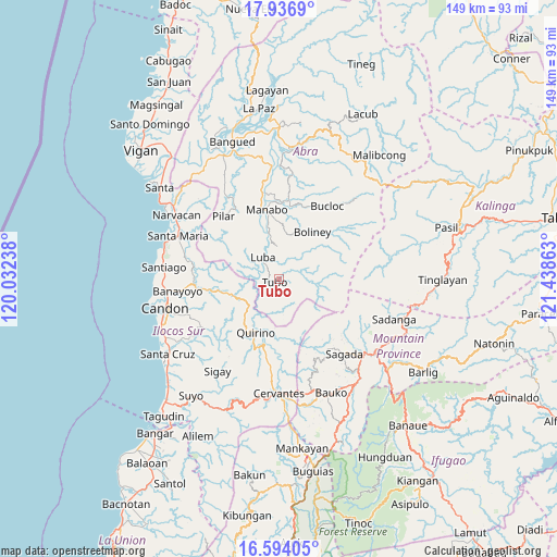
Tubo GPS coordinates[2]
17° 16' 0.12" North, 120° 44' 7.8" East
| Map corner | latitude | longitude |
|---|---|---|
| Upper-left | 17.9369°, | 120.03238° |
| Center: | 17.2667°, | 120.7355° |
| Lower-right: | 16.59405°, | 121.43863° |
| Map W x H: | 149.3×149.3 km | = 92.8×92.8mi |
| max Lat: | 20.78733° ⇑5.1% North |
| Tubo: | 17.2667° |
| min Lat: | ⇓94.9% South 4.65442° |
| min Long | Tubo | max Long |
| 117.04868° | 120.7355° | 126.58417° |
| W 16.1%⇐ | ⇒83.9% E |
Elevation
Elevation of Tubo is 333 m = 1093 ft, and this is 245.1 m = 804 ft above average elevation for this country.
| Max E: |
2262 m = 7421 ft | 6.8% |
| Tubo | 333 m 1093 ft | |
| Avg. | 87.9 m = 288 ft | |
Min E: |
-2 m = -7 ft | 93.2% |
See also: Philippines elevation on elevation.city.
Geographical zone
Tubo is located in North Torrid zone (between Equator and Tropic of Cancer). Distance of this Northern Tropic circle is 686 km =426.3 mi to North.| Distance of | km | miles | from Tubo |
|---|---|---|---|
| North Pole | 8087.2 | 5025.2 | to North |
| Arctic Circle | 5481.3 | 3405.9 | to North |
| Tropic Cancer | 686 | 426.3 | to North |
| Equator | 1919.9 | 1193 | to South |


Nearby cities:
15 places around Tubo: (largest is in red/bold)
• Bantay
19.2 km =11.9 mi,  7°
7°
• Besao
23.1 km =14.4 mi,  145°
145°
• Boliney
16.4 km =10.2 mi,  17°
17°
• Bucloc
23.4 km =14.5 mi,  34°
34°
• Gregorio del Pilar
20.1 km =12.5 mi,  220°
220°
• Lidlidda
22.7 km =14.1 mi,  270°
270°
• Luba
7.2 km =4.5 mi,  322°
322°
• Manabo
18.8 km =11.7 mi,  350°
350°
• Pilar
22.3 km =13.9 mi, 318°
• Quirino
14.2 km =8.8 mi,  209°
209°
• Salcedo
24.3 km =15.1 mi,  239°
239°
• San Emilio
13.9 km =8.6 mi,  251°
251°
• San Ramon
16.6 km =10.3 mi, 349°
• Sigay
25 km =15.5 mi, 215°
• Villaviciosa
22.3 km =13.9 mi,  328°
328°
Sources, notices
• [Note1] Compared only with cities in Philippines existing in our database
• [Src1] Map data: © OpenStreetMap contributors (CC-BY-SA)
• [Src2] Other city data from geonames.org with taken over terms of usage.
• [Src3] Geographical zone / Annual Mean Temperature by Robert A. Rohde @ Wikipedia
